Employing satellite data from NASA and Google Earth, Guofan Shao, a professor of geo-eco-informatics at Purdue University, has established that North Korea is logging Mount Paekdu Biosphere Reserve. Since North Korea is off-limits to most researchers, Shao has turned to open-access satellite data to monitor deforestation on the UN designated Man and Biosphere region.
“Particularly in the core area, there should be no human activity—no deforestation,” Shao said in a press release. “But when you look at the data with Google Earth, you can see the forest is no longer intact.”
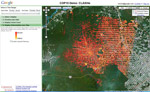
Shao first noticed changes in forest cover by looking at NASA satellite data, but to see closer resolution he turned to Google Earth. Their images showed the logging to be extensive: according to Shao, as much as 75 percent of the core areas forest has been lost.
“Hopefully more organizations, including governments, will pay more attention to the conservation issues there,” Shao said.
Home to the Siberian tiger, Mount Paekdu along with adjacent areas in China possesses the world’s highest plant diversity found in a cool, temperate zone.
Shao has asked to visit the site or to speak with North Korean officials, but his requests have been denied. He said he didn’t know if the logging was occurring to make way for expanded agriculture in a country known for large food shortages, or if loggers were simply extracting timber.
Mount Paekdu (also spelled ‘Baekdu’), which rises 2,744 meters, is sacred to Koreans as the founding site of Korea’s first kingdom known as Gojoseon.
Related articles
Google Earth boosts deforestation monitoring capabilities
(02/07/2010) Google has taken a step towards ramping up the deforestation monitoring capabilities the Google Earth Engine by contracting Massachusetts-based Clark Labs to develop an online version of its Land Change Modeler application.
Google’s Earth Engine to help tropical countries monitor forests
(12/16/2009) A powerful forest monitoring application unveiled last week by Google will be made freely available to developing countries as a means to build the capacity to quality for compensation under REDD, a proposed climate change mitigation mechanism that would pay tropical countries for protecting forests, according to a senior Google engineer presenting at a side event at COP15 in Copenhagen.
Google Earth to monitor deforestation
(12/10/2009) It what could be a critical development in helping tropical countries monitor deforestation, Google has unveiled a partnership with scientists using advanced remote sensing technology to rapidly analyze and map forest cover in extremely high resolution. The effort could help countries detect deforestation shortly after it occurs making it easier to prevent further forest clearing.