If current melting trends continue, the Arctic Ocean is likely to be free of summer sea ice by 2015, according to research presented at a conference organized by the National Space Institute at Technical University of Denmark, the Danish Meteorological Institute and the Greenland Climate Center.
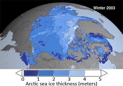
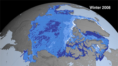
The estimates, which are consistent with some models presented at the American Geophysical Union meeting in 2007 and research published last year, are based on the rapid thinning (loss of volume) of Arctic sea ice, which has outpaced shrinkage in extent of sea ice, in recent years. Last month NASA announced that overall Arctic sea ice thinned about 17.8 centimeters (7 inches) a year, for a total of 67 cm (2.2 feet) over the four winters from 2004 to 2008. NASA said the total area covered by thick older ice that survives one or more summers (“multi-year ice”) shrank 42 percent or 1.54 million square kilometers (595,000 square miles), leaving thinner first-year ice (“seasonal ice”) as the dominant type of ice in the region. The share of seasonal ice increased from 38 percent of the Arctic’s total ice volume in 2003 to 68 percent in 2008.
|
|
Researchers say shifting currents and warmer waters are triggering ice melt, a process which builds on itself since sea ice helps reflect sunlight back into space, cooling the region. When sea ice melts, the dark areas of open water absorb the sun’s radiation, trigger a positive feedback loop that worsens melting. When there is less cloud cover, the effect is intensified.
Environmentalists are concerned that the loss of summer sea ice could have dramatic implications for wildlife — like polar bear and walrus — that depend on pack ice for feeding. At the same time, some developers welcome declining ice cover in that it could make it easier to exploit the Arctic’s rich mineral, oil and gas deposits. Melting has already triggered a scramble between Canada, Russia, the U.S., Denmark, Sweden and Norway over rights to seabed resources.
Greenland’s ice sheet
Scientists at the conference in Denmark also reported a “rapid increase” in ice loss for the Greenland ice sheet, including the loss of some 1200 cubic kilometers’ worth of ice over the past years. About 60 percent of the ice loss came from iceberg calving from glaciers, while 40 percent resulted from increased surface melting.
Researchers further reported that melting and calving is spreading across Greenland: “Up until now, the mass-loss has been concentrated in the southern part of the Greenland ice-sheet. And while the inland part of the ice sheet is still growing at a small rate each year, this rate is now also declining,” according to a statement from the Technical University of Denmark.
Conference presenters also said there is evidence that Greenland’s permafrost is thawing, raising the risk of increased greenhouse gas emissions from frozen methane deposits.
NASA reveals dramatic thinning of Arctic sea ice

(07/07/2009) Arctic sea ice thinned dramatically between the winters of 2004 and 2008, with thin seasonal ice replacing thick older ice as the dominant type of sea ice for the first time on record, report NASA researchers. Scientists from NASA and the University of Washington used observations from NASA’s Ice, Cloud and land Elevation Satellite (ICESat) to make the first Arctic Ocean basin-wide estimate of the thickness and volume of sea ice cover. The researchers found that overall Arctic sea ice thinned about 17.8 centimeters (7 inches) a year, for a total of 67 cm (2.2 feet) over the four winters from 2004 to 2008. The total area covered by thick older ice that survives one or more summers (“multi-year ice”) shrank 42 percent or 1.54 million square kilometers (595,000 square miles), leaving thinner first-year ice (“seasonal ice”) as the dominant type of ice in the region.
How satellites are used in conservation

(04/13/2009) In October 2008 scientists with the Royal Botanical Garden at Kew discovered a host of previously unknown species in a remote highland forest in Mozambique. The find was no accident: three years earlier, conservationist Julian Bayliss identified the site—Mount Mabu—using Google Earth, a tool that’s rapidly becoming a critical part of conservation efforts around the world. As the discovery in Mozambique suggests, remote sensing is being used for a bewildering array of applications, from monitoring sea ice to detecting deforestation to tracking wildlife. The number of uses grows as the technology matures and becomes more widely available. Google Earth may represent a critical point, bringing the power of remote sensing to the masses and allowing anyone with an Internet connection to attach data to a geographic representation of Earth.
Climate change doubles coastal erosion in Alaska over 5-year period
(02/18/2009) Coastal erosion along a 64-kilometer (40-mile) stretch of Alaska’s Beaufort Sea doubled between 2002 and 2007, report researchers, who link the development to “declining sea ice extent, increasing summertime sea-surface temperature, rising sea level, and increases in storm power and corresponding wave action.”
As sea ice retreats, swathe of Arctic closed to fishing

(02/06/2009) The North Pacific Fishery Management Council (NPFMC) voted unanimously to close off more than 150,000 square nautical miles of the Arctic sea to commercial fishing. The decision, welcomed by an array of environmentalists and industry groups, is a preventative measure to protect fisheries that have become more accessible as a result of declining sea ice in the Arctic. It is the first time that the federal government has closed a fishery due to climate change instead of over-fishing, says supporters of the ban.
Global warming to strengthen Arctic storms
(02/05/2009) Arctic storms could worsen due to climate change, putting fisheries, oil and gas exploration, and sea lanes at risk, warn researchers writing in the journal Climate Dynamics.
Arctic sea ice fell to the lowest volume on record in 2008
(12/17/2008) Arctic sea ice fell to the lowest volume — and second lowest extent — on record, according to the annual World Meteorological Organization (WMO) Statement on the Status of the Global Climate.
Observed sea level rise, ice melt far outpaces projections

(12/17/2008) Sea levels will rise faster than previously estimated due to rapid melting of glaciers and ice sheets, according to a U.S government report released at the annual meeting of the American Geophysical Union in San Francisco. The report, titled Abrupt Climate Change, incorporates research published since last year’s Intergovernmental Panel on Climate Change (IPCC) report, which drew largely from studies dating up to 2006. Most significantly, Abrupt Climate Change suggests that IPCC estimates for future sea level rise (18-58 cm) are conservative, noting that recent observations on sea level rise and loss of sea ice are far outpacing previous projections.
b>NOAA offers “dramatic evidence” of Arctic warming
(10/16/2008) Fall air temperatures 9°F (5°C) above normal, the second lowest-ever extent of summer sea ice, and the melting of surface ice in Greenland are signs of continued warming in the Arctic, according to the Arctic Report Card, an annual review of Arctic conditions by U.S. National Oceanic and Atmospheric Administration (NOAA) and its partners.
NASA: Sea ice melt opens the Northwest and Northeast Passage
(09/09/2008) An image released by NASA shows that Arctic sea ice has retreated to the point where both the Northwest Passage around North America and the Northern Sea Route around Russia are open simultaneously. The occurrence marks the first time on record that both passages have been open.
Canada’s ice shelves lost 23% of their area this summer
(09/03/2008) A 19-square-mile (50 sq km) chuck of ice shelf broke off from Canada’s Ellesmere Island in the northern Arctic, reports the Associated Press. The Manhattan-sized ice shelf is now adrift in the Arctic Ocean. It is the largest of more than 83 sq mi (214 sq km) of ice shelf that has broken up in the Canadian Arctic this year.
Sea ice loss may triple warming over northern Alaska, Canada, and Russia
(06/11/2008) Fast-declining Arctic sea-ice could spur rapid warming in northern Alaska, Canada, and Russia triggering thawing of permafrost and a release greenhouse gases from the frozen soils, reports a new study published in Geophysical Research Letters.
Perennial ice disappearing in the Arctic receives little attention from the media
(03/19/2008) A big story came out on the loss of perennial ice in Arctic from NASA on Wednesday — and was mostly ignored by the media. Despite a colder winter than usual, the Arctic is losing its perennial ice (ice that lasts longer than a season) making the region even more susceptible to global warming. Perennial ice used to cover 50-60 percent of the Arctic. Results from this year’s satellites show that perennial ice has decreased to less than 30 percent. In addition ice older than six years has declined from 20 percent in the eighties to six percent today.
Arctic sea ice extent hits record low in September
(10/16/2007) Arctic sea ice reached a record low in September 2007, well below the previous record set in 2005 and substantially below the long-term average, according to an image released by NASA.
Northwest Passage now open for business
(09/15/2007) Melting sea ice has opened the Northwest Passage in the Arctic to navigation, reports the European Space Agency. The clearing allows direct access between the North Pacific and North Atlantic and could eventually be a cheaper shipping route that the Panama Canal.
Arctic sea ice thickness only half of 2001 level
(09/14/2007) Arctic sea is thinning and disappearing, report German researchers. An Alfred-Wegener-Institute for Polar and Marine Research expedition to the North Polar Sea found that large areas of the Arctic sea-ice are only one meter thick this year — half the thickness found in 2001. The findings support concerns that large expanses of polar ice could soon disppaear from the Arctic during summer months.


