|
|
Three satellite images released by the European Space Agency (ESA) reveal a dramatic shrinking of the Aral Sea from 2006 to 2009.
The Aral Sea was until recently the world’s fourth-largest inland body of water (at 68,000 square kilometers), but has steadily disappeared since the 1960s due to water diversion for irrigation. By 2000 the sea had split in an eastern lobe and a western lobe.
The new Envisat images show the eastern lobe, shared by Kazakhstan and Uzbekistan, has lost about 80 percent of its surface area since 2006. The southern section of the sea is expected to dry out completely by 2020, according to ESA.
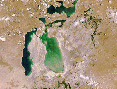 Envisat acquired these images on 1 July 2006 and 6 July 2009 with its Medium Resolution Imaging Spectrometer (MERIS) instrument while working in Full Resolution Mode to provide a spatial resolution of 300 m. |
As the sea has evaporated, the dry lake bed left behind has contributed to violent sandstorms that have interfered with transportation and agriculture, and caused detrimental health impacts to local populations. ESA reports that the sandstorms have made regional winters colder and summers hotter.
In an effort to reduce sandstorms and save at least some parts of the sea, local authorities have begun planting the lake bed with salt-tolerant vegetation and building dikes. Since its completion in 2005 the Kok-Aral dike, a joint project of the World Bank and the Kazakhstan government, has shored up the northern section of the sea, causing the water level to rise by an average of 4 m. But the dike has come at a cost: it has diverted water from the southern portion of the sea, accelerating drying.