|
|
The establishment of protected areas on the Indonesian island of Sumatra may have helped reduce deforestation in adjacent unprotected areas, reports new research published in Journal of Biogeography. The results run counter to recent studies elsewhere that suggest the establishment of nature reserves attracts development projects and migrants to surrounding areas, undermining overall conservation efforts.
Analyzing 98 LANDSAT satellite images across Sumatra and the smaller island of Siberut from 1990 to 2000 and applying a statistical method known as “propensity score matching”, David Gaveau and colleagues found that “a reduction in deforestation rates inside Sumatran protected areas has promoted protection, rather than deforestation, in adjacent unprotected land lying within 10 km of protected area boundaries.”
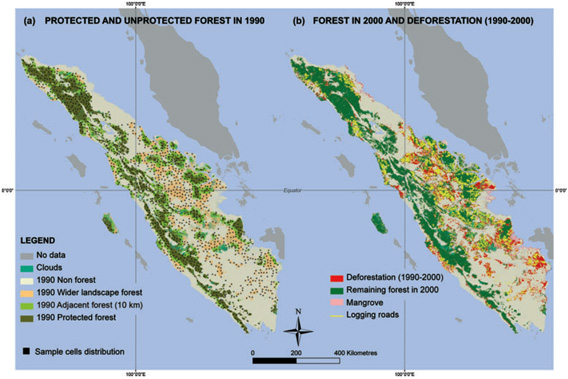 (a) Protected and unprotected forests in 1990 for the main island of Sumatra and the smaller island of Siberut, including adjacent unprotected land lying within 10 km of protected area (PA) boundaries and the wider unprotected landscape, and showing the spatial distribution of the 1264 sample cells (25 km2). (b) Remaining forests in 2000, deforestation and logging trails occurring during the period 1990–2000 (UTM projection, WGS84). Protected areas (PAs) protecting mangroves or created after 2000 are not shown. MAPS available at sumatranforest.org |
“We report the absence of a ‘detrimental neighborhood leakage’ effect around Sumatran reserves, indicating that Sumatran PAs have not attracted population growth and development projects along their boundary,” lead author David Gaveau, a researcher at the Durrell Institute of Conservation and Ecology of the University of Kent, told mongabay.com via email. “Instead, this study provides evidence for the presence of a ‘beneficial neighborhood leakage’ effect. It appears that reducing deforestation inside Sumatran protected areas has promoted protection to adjacent unprotected areas.”
But Gaveau and colleagues caution that their findings may be explained by demographic changes — specifically depopulation of rural areas due to urbanization — rather than the influence of conservation efforts extending beyond park boundaries.
“Whether Sumatran protected areas extend their conservation influence beyond their boundary may prove controversial, because enhanced law enforcement and ecotourism activities on private lands around protected areas are not well developed on the island of Sumatra,” they write. “The unexpected presence of a beneficial leakage effect that conserves forests adjacent to protected areas may be explained by an island-wide decreasing population growth effect near Sumatran protected areas as human population moves closer to urban centers.”
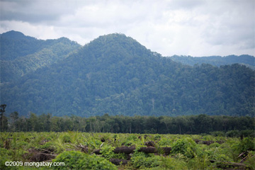 Oil palm plantation and forest in North Sumatra |
The authors also note that their optimism for the success of protected areas in reducing deforestation is tempered by the continued loss of forest in Sumatra. Between 1990 and 2000 Sumatra lost at least 50,078 square kilometers of forest, 25.6 percent of its forest cover, while 49,020 kilometers of logging roads had been built in remaining forest areas. While 91.7 percent of deforestation occurred in unprotected areas, “more than 35 percent of the Sumatran protected set aside to conserve biodiversity… had experienced severe rates of forest loss (> 1% year)… [and] 60% had been encroached by mechanized logging operations.”
“The real question for policy makers is not whether tropical PAs have lower rates of deforestation than unprotected areas, but rather whether the long-term viability of tropical forests has been secured by establishing protected areas,” the authors conclude.
Maps online at SumatranForest.org.
David L. A. Gaveau, Justin Epting, Owen Lyne, Matthew Linkie, Indra Kumara, Markku Kanninen and Nigel Leader-Williams. Evaluating whether protected areas reduce tropical deforestation in Sumatra. Journal of Biogeography (J. Biogeogr.) (2009) www.blackwellpublishing.com/jbi doi:10.1111/j.1365-2699.2009.02147.x
Related articles
Deforestation maps for Sumatra now available on Google Earth
(03/31/2009) Despite many years of research in conservation biology, precise maps of tropical deforestation that document the global spatial extent of tropical forests destruction are generally not available outside of the scientific community, says David Gaveau a researcher from Durrell Institute of Conservation and Ecology (DICE) points out. For nearly seven years, Gaveau has been documenting forest destruction on the entire island of Sumatra since early 1970s using satellite technology, and he has found the way to make his full-resolution maps and scientific results public using Google Earth.
Parks help people to the detriment of biodiversity, suggests study
(07/03/2008) The establishment of nature reserves in Africa and Latin America has been a boon to human settlement but comes at a cost to biodiversity, suggests a new study published in the journal Science. Analyzing 306 rural protected areas in 45 countries in Africa and Latin America, George Wittemyer and colleagues found that the rate of human population growth along the borders of reserves was nearly twice that of neighboring rural areas.