How a researcher developed the world’s most sophisticated program for mapping endangered species
Developing the world’s most sophisticated program
for mapping endangered species:
An Interview with Steven Phillips of AT&T Labs
Jemery Hance, mongabay.com
August 4, 2008
|
|
It was big news in April when a comprehensive map of Madagascar’s rich and unique biodiversity was unveiled. The project managed to map ranges of 2,315 species across an island larger than France. Such detailed mapping could not have happened without the aid of Steven Phillips. A researcher at AT&T, Phillips developed the software that made such detailed and expansive mapping possible.
The findings of the map were surprising, showing pockets of area in Madagascar that deserve protection but had neglected thus far, in addition to larger, more known areas. The new system will aid conservations and the government of Madagascar as they attempt to choose the most important places for protection. President Ravalomanana has committed to protecting 10 percent of the Madagascar’s land for its unique wildlife.
Working closely with conservation scientists—and still tweaking his program—Phillips developed software that has quickly become an invaluable tool for saving wildlife in Madagascar—and around the world. Below, he tells mongabay.com how he did it.
Mongabay: How did you get involved in developing the software for the biodiversity map of Madagascar?
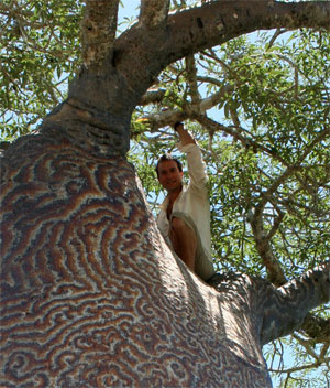 Steven Phillips in a tree in Madagascar |
Steven Phillips: A few years ago I was doing some volunteer programming for the Center for Biodiversity and Conservation at the American Museum of Natural History. Some ecologists there were modeling species distributions from museum collection records, and I realized that this modeling task offered an opportunity to do computer science research and contribute to conservation efforts at the same time.
Mongabay: How do you make the jump, technologically, from working with telecommunication networks to creating software for mapping regions and wildlife of a country the size of Madagascar?
Steven Phillips: As a researcher at AT&T Labs, I have the luxury of setting my own research agenda. I generally work on algorithms and optimization — finding efficient ways to solve large problems, such as designing and managing continental-scale telecommunications networks. However, it was clear to me that developing a new approach to species distribution modeling entailed research in machine learning, and I hadn’t worked in that area before. So, I walked into the office of Rob Schapire, a star researcher in AT&T Research’s machine learning group at the time. I described the modeling task to him and asked his advice, and without any hesitation he suggested using a “maximum entropy” approach. We’ve been working together on Maxent ever since, together with Miro Dudik, who was Rob’s first Ph.D. student after Rob moved to the computer science department at Princeton. I’ve gotten to learn about machine learning along the way, and learnt some ecology too!
Mongabay: How long did the development of the software take?
Steven Phillips: The first version of the software was ready in just a couple of months, but we’ve continued working on it on and off for about six years, refining it and adding new features. Biodiversity data is very challenging to work with — the most important species for conservation are often the rarest and hardest to find, so there are very few records to use for modeling, and the records have strong geographic collection biases reflecting the difficulty of reaching and working in some of the areas where the species live. This makes the modeling task challenging, and has led us to a number of interesting theoretical questions in machine learning. We’ve made perhaps a dozen software releases, with the new features deriving both from our theoretical research and from requests from ecologists using of the software.
Mongabay: Can you explain to us how the software works?
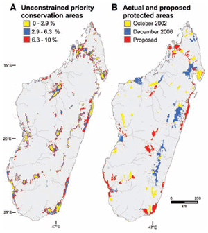 Conservation priority zones in Madagascar. (A) Unconstrained multitaxon solution, showing what would have been selected based on these 2315 species if no areas were already protected. Colors indicate priority level: The topranked 2.9% priority areas are shaded yellow (equivalent to the area actually protected by 2002), the next-ranked priorities to 6.3% are blue (equivalent to the area actually protected by 2006), and the nextranked priorities to 10% (equivalent to the conservation target) are red. (B) Constrained multitaxon solution, expanding (red) from existing parks in 2006 (yellow + blue = 6.3% of area) to 10% protection. The red areas are thus those that our analysis selects as the most important areas to consider for expansion of the current reserve network. Image and camption text courtesy of Kremen et al. SCIENCE VOL 320 11 APRIL 2008 |
Steven Phillips: Maxent uses a collection of locations where a species has been found, together with environmental conditions (such as rainfall and temperature) across the study area, to produce an estimate of the species’ distribution in the study area. It does this by inferring a set of constraints on the species distribution, based on environmental conditions at the presence locations: for example, if most of the presence locations have annual average temperature above 20 degrees Celsius, we infer that the species likes warm conditions, so most of its distribution should be above 20 degrees. Among all possible distributions that satisfy the constraints, Maxent finds the largest, most spread-out distribution, i.e., the distribution of maximum entropy. Because we maximize entropy, we get a prediction that shows the full extent of areas with similar environmental conditions to the places where the species has been found.
Mongabay: Do you think this software could be implemented for conservation efforts in other places of the world?
Steven Phillips: Yes, and it is already being used around the world. It’s available free on the web for non-profit and research use, and has been downloaded thousands of times, from about 60 different countries.
Mongabay: Do you plan to continue working with this software? What are some future changes you would like to see?
Steven Phillips: We’re getting ready to release a new version of the software, but the new features are quite small now. One topic I’m very interested in is climate change, which is going to cause major distribution shifts. We need to protect species not only where they are now, but where they’ll need to be in 50 or 100 years, and we need to facilitate their movement if those areas don’t overlap. If we find any general ways of improving the accuracy of predictions of species’ future distributions, I’d certainly like to incorporate them into Maxent.
Mongabay: What other projects are researchers in AT&T labs working on?
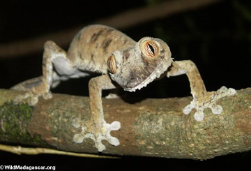 The leaf-tailed gecko (Uroplatus fimbriatus) is found on the island of Madagascar. |
Steven Phillips: I can’t speak for the whole Labs, but I can describe a few projects that I know of that relate to the environment. We’re using an approach widely used to optimize flows of data through telecommunications networks to model flows of organisms across a landscape. We’ve applied it to the proteas, a family of about 300 beautiful flowering plants species in South Africa, to determine how much land would need to be conserved to allow all species to migrate through protected areas in response to climate change. We used integer programming to optimize the configuration of ponds and salt marshes in the South San Francisco Bay, where former evaporative salt ponds are now being managed for bird conservation. This summer, a student on an AT&T graduate fellowship has been working at the Labs on applying optimization methods to “irreplaceability,” a way of measuring the relative importance of potential sites to purchase for conservation. Another fun project, unrelated to the environment, is an exhibit currently at the Museum of Modern Art in New York, where real-time data from AT&T’s network are used to show shifting patterns of communication between New York and the rest of the world.
Mongabay: Did you have an interest in Madagascar or wildlife prior to working on this project?
Steven Phillips: Absolutely. I feel very strongly about conservation of wildlife, because my generation has an extraordinary responsibility—a quarter of all species on earth are likely to be driven to extinction during our lifetimes, and we can’t just stand aside and watch. Madagascar is of particular interest, both because it is arguably the hottest of the hot spots (areas of the world with a high concentration of rare and endangered species) and because there is political will to protect Madagascar’s biodiversity: President Ravalomanana has committed to protecting 10% of the land area in national parks, up from 2.8% in 2003.
Mongabay: Have you had a chance to visit Madagascar? If so, how was the trip? If not, what would you most like to see there?
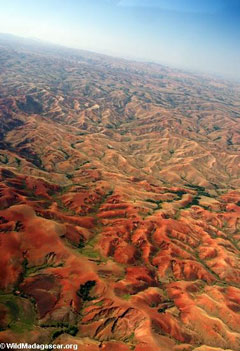 Deforestation in Madagascar. |
Steven Phillips: I was lucky to visit Madagascar for the first time in January. Most of the trip was work—teaching a group of Malagasy students about species distribution modeling then attending a workshop on conservation and climate change. I had a week and a half to travel, which was just enough to get a taste of Madagascar’s diversity. I spent a couple of days in the rainforest at Andasibe, where the highlight was standing just a few feet from a family of Indri, the largest of the remaining lemur species, while they sang their ear-splitting but lovely territorial song. My visit ended with trip through the spiny desert of the southwest to visit a Wildlife Conservation Society conservation program at Andavadoaka. The spiny desert is other-worldly, brimming with wonderful and highly specialized plant species like the octopus tree and almost spherical baobab trees. It was clear why this unique area emerged as a priority in our conservation mapping project, and I’m hopeful that our study will help ensure its conservation.
Mongabay: The Madagascar mapping project made was the top story in Science Magazine and a video regarding your work from AT&T has made its way to YouTube—did you expect such a response from your work?
Steven Phillips: No, I didn’t expect it at all! I’m very happy about the response, both for the high profile given to the work by Science Magazine, and for the enthusiastic support AT&T has given and continues to give to my conservation research.