Could hurricane Gustav be stopped or diverted?
Could hurricane Gustav be stopped or diverted?
mongabay.com
August 31, 2008
|
|
With Gustav threatening to become the second major hurricane to hit New Orleans in three years, the question emerges, is there something that could be done to redirect or at least diminish storms from major population areas? In short, the answer is no, although someday there may be ways to reduce the intensity of these tropical storms. In the meantime, the best option is to avoid new construction in hurricane-prone regions.
In the 1960s and 1970s, the United States government attempted to weaken hurricanes by seeding storms with silver iodide (China recently used the technique in an attempt to induce rainfall to clear the skies of pollution at the Beijing Olympics). The experiment, called Project Stormfury, sought to test the theory that the seeding would augment precipitation outside the storm’s eyewall, causing it to collapse and thus reduce the winds. The experiment proved inconclusive but it seems unlikely that such a mechanism could significantly impact the strength of a large hurricane.
Today researchers are experimenting with other approaches to moderate hurricanes and tropical storms. Some meteorologists believe that small changes in the temperature in and around a hurricane can shift its path or disrupt its intensity.
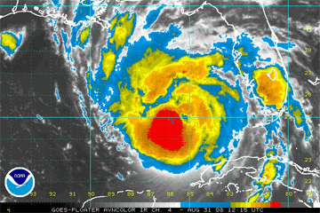 AVN Satellite Image of hurricane Gustav. Courtesy of the National Oceanic and Atmospheric Administration (NOAA) Hurricane formation |
Scientists at the Atmospheric and Environmental Research (AER), an R&D consulting firm, are modeling hurricanes to see what effect atmospheric heating might have on their path and strength. In a 2004 Scientific American article Ross N. Hoffman of AER suggests that an array of earth-orbiting solar power stations could eventually be used to supply sufficient energy for the disruption of hurricanes. By heating an area of ocean, scientists in the future may be theoretically able to “steer” a hurricane off its projected path if it threatens population centers. Hoffman concedes though that the amount of energy needed to achieve such an objective would be substantial.
Since hurricanes draw their power from evaporating sea water, cutting off the supply of warm water available to them could reduce their strength. Operating on this premise, Hoffman suggests another tactic involving the application of “a thin film of a biodegradable oil” to slow the evaporation that serves as the fuel for a hurricane. A great deal more research is needed to determine where such a strategy is feasible especially with a large hurricane that may cover hundreds of square miles of ocean surface.
Other approaches involving the towing of icebergs or detonation of nuclear weapons pose more risk that potential meteorological protection.
Meteorological control raises other concerns
While technical solutions to such weather phenomena may someday be possible, there are a host of issues that must be resolved. For example, who would determine what tropical storms and hurricanes would be targeted? Each year there are several dozen weather disturbances, of which only five or so actually become hurricanes. Further, “what if intervention causes a hurricane to damage another country’s territory?” asks Hoffman. Or, what if countries start to use weather as a weapon of mass destruction?
At the moment these questions are somewhat academic. For now the focus should be on the wisdom of continuing to build on lands that are highly susceptible to hurricane damage. As the oceans warm, hurricanes are only going to get stronger and pose an ever greater threat to low-lying cities and coastal areas like New Orleans.
Hurricane Gustav
Hurricane Gustav, currently a category 3 hurricane, is expected to make landfall somewhere between Cameron, Louisiana eastward to the Alabama-Florida border. The area includes the city of New Orleans and Lake Pontchartrain which were devastated by hurricane Katrina in August 2005.
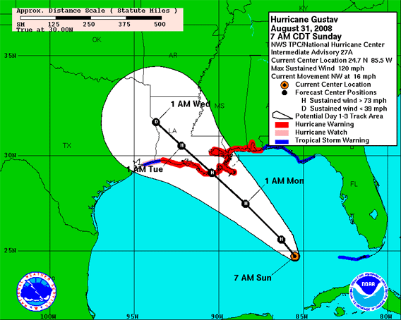 This graphic shows an approximate representation of coastal areas under a hurricane warning (red), hurricane watch (pink), tropical storm warning (blue) and tropical storm watch (yellow). The orange circle indicates the current position of the center of the tropical cyclone. The black line and dots show the National Hurricane Center (NHC) forecast track of the center at the times indicated. The dot indicating the forecast center location will be black if the cyclone is forecast to be tropical and will be white with a black outline if the cyclone is forecast to be extratropical. If only an L is displayed, then the system is forecast to be a remnant low. The letter inside the dot indicates the NHC’s forecast intensity for that time. NHC forecast tracks of the center can be in error; track forecast errors in recent years were used to construct the areas of uncertainty for the first 3 days (solid white area) and for days 4 and 5 (white stippled area). These areas of uncertainty are formed by enclosing the area swept out by a set of circles (not shown) along the forecast track (at 12, 24, 36 hours, etc). The size of each circle is set so that two-thirds of historical official forecast errors over a 5-year sample fall within the circle. The historical data indicate the entire 5-day path of the center of the tropical cyclone will remain within the outer uncertainty area about 60-70% of the time. There is also uncertainty in the NHC intensity forecasts. The Maximum 1-minute Wind Speed Probability Table provides intensity forecast and uncertainty information. It is also important to realize that a tropical cyclone is not a point. Their effects can span many hundreds of miles from the center. The area experiencing hurricane force (one-minute average wind speeds of at least 74 mph) and tropical storm force (one-minute average wind speeds of 39-73 mph) winds can extend well beyond the white areas shown enclosing the most likely track area of the center. The distribution of hurricane and tropical storm force winds in this tropical cyclone can be seen in the Wind History graphic linked above. Caption text and image courtesy of the National Oceanic and Atmospheric Administration (NOAA) |
Related
Natural climate variations have larger effect on hurricanes than global warming
(12/12/2007) Natural climate variations, which tend to involve localized changes in sea surface temperature, may have a larger effect on hurricane activity than the more uniform patterns of global warming, a report in this week’s Nature suggests.
Could a hurricane hit California?
(8/20/2007) San Diego has been hit by hurricanes in the past and could be affected by such storms in the future according to data from the National Oceanic and Atmospheric Administration (NOAA). While a hurricane in San Diego would likely produce significantly less damage than Hurricane Katrina in New Orleans, it could still exact a high cost to Southern California especially if the region was caught off guard.
Caves may reveal if global warming is causing stronger hurricanes
(1/29/2007) Scientists have shown that cave formations could help settle the contentious debate on whether hurricanes are strengthening in intensity due to global warming. Measuring oxygen isotope variation in stalagmites in Actun Tunichil Muknal cave in central Belize, a team of researchers have identified evidence of rainfall from 11 tropical cyclones over a 23 year period (1978-2001). The research — the study of ancient storms is called paleotempestology — could help create a record of hurricanes that would help researchers understand hurricane frequency and intensity. “Tropical cyclones (including hurricanes, tropical storms, typhoons, and cyclones) produce rainwater that is different from other summertime precipitation,” explained Amy Benoit Frappier, an assistant professor in the Department of Geology and Geophysics at Boston College and lead author of the study published in Geology. “Tropical cyclones produce isotopically light rainwater primarily because 1) their cloud tops are very high and cold, and 2) their humid air tends to prevent lighter water molecules from evaporating back out of the raindrop as they fall.”