Indigenous peoples of Congo map their forests with GPS in an effort to save them
Indigenous peoples of Congo map their forests with GPS in an effort to save them
Jeremy Hance, mongabay.com
April 13, 2008
|
|
This week over five hundred villagers in the Democratic Republic of Congo’s rainforest will employ GPS technology to map their forests in an effort to preserve their territory from logging companies.
This large-scale community initiative is being managed by the Rainforest Foundation UK (RFUK), which has trained 66 ‘Master Mappers’ to aid the villagers in mapping their territories using motorbike and canoe. The villages are mapping their full territory in the Congo, but are also employing the GPS to mark significant areas including their villages, sacred places, and fishing and hunting areas.
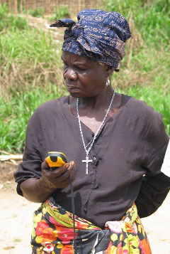 Elisa Folo with GPS. Courtesy of RFUK |
The Congo is the world’s second largest rainforest. It has suffered greatly from two civil wars in the Democratic Republic of Congo (DRC). The first lasted from 1996-1997; the second from 1998-2003. The second conflict, sometimes referred to as Africa’s World War, holds the dubious distinction of being the deadliest conflict since World War II. During these devastating wars, militias and armies exploited the rainforest and its indigenous peoples with impunity. Since the war’s end, the political stabilization of the DRC have meant that its forests are under new pressures, this time by industrial and often international logging companies.
“There is a rush for the trees,” according to Rene Ngongo, from the local NGO, Organisation Concertée des Ecologistes et Amis de la Nature (OCEAN), which is working with the RFUK. “What is at stake is enormous. Two-thirds of the people in Congo depend on this forest to provide food, medicines and building materials. It is critical for the survival of the people and animals.”
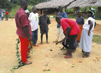 Mapping Balele. Courtesy of RFUK |
The natives of the forest have largely been left out of forest policy thus far; the hope is that these maps will change that. “It is going to be the first time that anybody in DRC sees on paper that these forest-dependent communities exist,” Cath Long, RFUK Project Director said. “Their maps will be a vital tool for the communities to negotiate with the government. It will allow them to demonstrate that they are there, and that they need to be taken into account when decisions are made about the forest they live in.”
The maps are to be completed by May 8th, in time for a meeting where the DRC government will decide how various territories of the forest will be used. The meeting could affect forest policy in the DRC for decades. For indigenous villagers, who have already seen portions of their territory handed over to logging companies, this is an opportunity to make their voice heard.
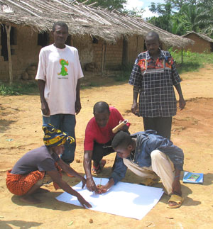 Balele group mapping. Courtesy of RFUK |
Simon Counsell RFUK Director adds that the preservation of the Congo rainforest, or lack thereof, could no longer be considered purely a regional question. “This is an issue that affects us all because not only are rainforests home to an estimated 50 million indigenous forest peoples and more species of plants and animals than all the earth’s other ecosystems combined, but also because protecting the forests is essential in the fight against climate change”.