Fire monitoring by satellite becomes key tool for conservation
Fire monitoring by satellite becomes key conservation tool:
An interview with GIS experts at Conservation Interational and the University of Maryland
Rhett A Butler, mongabay.com
March 27, 2008
Remote sensing is increasingly used as a tool for conservation management. Beyond traditional satellite imagery popularized by Google Earth, new sensing applications are allowing researchers located anywhere in the world to track fires, illegal logging and mining, and deforestation in some of Earth’s most isolated regions using a computer or handheld device.
The Fire Alert System and FIRMS are two examples of applications that harness the power of satellites to deliver key data to conservation managers. Developed by Madagascar’s ministry of Environment, the International Resources Group, Conservation International using data from the University of Maryland and NASA, the Fire Alert System enables near real-time monitoring of fires anywhere on the island of Madagascar, a hotspot of biological diversity. The system, which sends subscribers regular email alerts on newly-detected burning, will eventually be expanded to include fire risk and related activities like road building and illegal logging. FIRMS is a global fire monitoring and alert system for protected areas; it delivers MODIS active fire data and imagery to natural resource managers in a range of in easy-to-use formats.
In a March 2008 discussion with mongabay.com, Leanne Miller (Spatial Data Manager at Conservation International), John Musinsky (Senior Director of the Regional Analysis & GIS Laboratory at Center for Applied Biodiversity Science of Conservation International), and Diane Davies (Department of Geography at the University of Maryland) explained how remote sensing is being applied to conservation efforts.
Mongabay: Can you briefly describe what the Fire Alert System is and how it works?
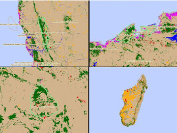
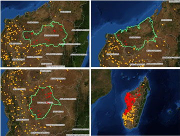
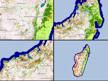
Key biodiversity area boundaries over CI’s forest cover and clearance 1975-2000 project.
Region boundaries over NASA’s Blue Marble Product.
Region boundaries over the Royal Botanic Gardens, KEW Vegetation Type Product. Fires in red are in areas of interest. Fires in orange are in surrounding areas. |
John Musinsky: The purpose of CI’s Fire Alert System is to deliver near real-time satellite observations of fires to the government agencies, NGO’s and community organizations responsible for natural areas management and fire suppression in countries where CI works. We originally developed the concept of fire alerts for protected areas when we learned about the University of Maryland’s Web Fire Mapper. The University of Maryland and NASA had developed an automated fire detection system based on daily satellite observations obtained by MODIS, and UMD posted these results within an interactive mapping website called Web Fire Mapper. Our contribution was simply introducing the idea of extending the capability of Web Fire Mapper to include an email-based “push” system that would deliver email alerts with jpg attachments to subscribers interested in fires occurring within particular protected areas. We created an initial prototype of the system based on manually generated alerts for protected areas in seven countries utilizing the active fire data from UMD, and UMD subsequently won a NASA grant to develop a more comprehensive system called FIRMS (Fire Information for Resource Management System) that allows one to subscribe to email alerts for any protected area in the world (at least those contained in the WCMC-UNEP World Database on Protected Areas). We have thus suspended our generation of fire alerts for protected areas in six of the seven countries as these data would essentially duplicate those of FIRMS. Note that other fire alert systems (and web mapping systems) have since been developed by INPE (Brazil’s national space agency) and CONABIO (Mexico’s national institute on biodiversity) that generate automated alerts for fires within their national territories based on MODIS and GOES satellite data.
We did not abandon the idea of creating an automated fire alert system, however, and in partnership with International Resources Group received funding from USAID to develop a specialized fire alert system tailored to the specific needs of Madagascar’s Ministry of the Environment (MinEnvEF – Ministere de L’Environnement des Eaux et Forets). This system functions in French and English and allows the subscriber to select among a wide array of environmental, political and administrative boundary layers for which to receive fire alerts. We are also developing a satellite-based fire risk prediction system that utilizes a fire-risk model developed by the US Forest Service. This fire risk monitoring system will generate maps that can be bundled with active fire data for posting on the web or included in email alerts.
Mongabay: Is the Fire Alert System being used for other applications like detecting illegal logging?
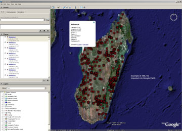
Google Earth KML with NASA Modis data |
John Musinsky: As part of our efforts to help local counterparts in Indonesia improve enforcement and more effectively protect national parks and reserves against illegal activities such as logging, hunting and forest conversion, we are using a range of satellite data to detect suspected illegal activity as quickly and accurately as possible, and distributing these detections through suspected illegal activity alerts, including fire alerts. However, within Indonesian parks, fire is most frequently an indicator of larger-scale activity such as slash-and-burn agriculture rather than an indicator of selective logging or road building. And on any given day, cloud cover may prevent detection of active fires, which means it is important to follow-up with satellite data analysis to determine the location and extent of forest conversion that may have resulted through the use of fire. We are therefore complementing fire alerts with illegal logging alerts derived from the analysis of fine-scale optical satellite data to determine where new illegal activity is suspected to be occurring.
In the case of Indonesia, one of our partners — Fauna and Flora International — reported on the effectiveness of the fire alerts for tracking illegal activity along the Bengkulu-South Sumatra provincial borders within Kerinci Seblat National Park, one of which led to the discovery and expulsion of illegal loggers and squatters.
 Leanne Miller |
 John Musinsky |
 Diane Davies |
Mongabay: How do you envision the Fire Alert System being expanded in the future?
John Musinsky: While we were originally interested in creating a global fire alert system for protected areas, this has been accomplished most effectively by the UMD team. We have therefore decided that — in the event the FIRMS alerts are not adequate (e.g., more site-specific content is needed) — our efforts are best spent working with local counterparts in a small number of countries to generate specialized alerts, analyses, reports and training tailored to their individual needs.
Mongabay: How is the system being used for conservation in Madagascar?
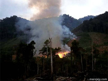
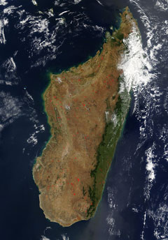
Fire in Madagascar. Photo by Paul Atkinson |
Leanne Miller: The impact of fires can be devastating and dramatic for humans and wildlife. It can contribute to shifting land cover types and modifying nutrient cycles. The Fire Alert System provides near real-time fire point locations to MinEnvEF – Ministere de L’Environnement des Eaux et Forets, local and international NGOs, and partners working on fire fighting or fire prevention in Madagascar. In August 2007, several regional workshops were held to help organizations and individuals understand how this system could be useful to their efforts and how to subscribe. The results of these workshops were that currently 16 regions with Madagascar have plans to receive and use the data. Approximately six hundred people received information from these workshops. In the spring of 2008, Conservation International (CI) and International Resources Group (IRG) through the JariAla project have plans to host a Lessons Learned workshop to built on current users experiences and improve services based on user feedback.
Mongabay: What is the response from conservation managers when presented with the capabilities of Fire Alert System?
Leanne Miller: On September 23, 2007 CI-Madagascar, IRG, and the MinEnvEF – Ministere de L’Environnement des Eaux et Forets hosted a public launch of the Fire Alerts System. Fifteen media stations where invited to this event held in Antananarivo, Madagascar. NGOs, the Ministry, and other partners that participated expressed great interest in the service and products available. There was particular interest in the application of KML files that could be used within Google Earth software.
Mongabay: How does the Fire Information for Resource Management System (FIRMS) work?
Diane Davies: FIRMS was developed under NASA’s Applied Sciences Program. It aims to increase the accessibility of MODIS Fire data to natural resources managers around the world. By providing these data in easy to use formats we are broadening access to satellite derived products that were once available only to users with good internet access and some remote sensing expertise.
In a nutshell, global MODIS data are processed in near-real-time by the MODIS Rapid Response System, active fire locations are generated using a global thermal anomalies algorithm (MOD14) and these fire coordinates are ingested into FIRMS from where they are made available in a number of formats including a web mapping interface called Web Fire Mapper, as email alerts, text files, ESRI shape files and through files that can readily be viewed in virtual globes such as Google Earth and NASA World Wind.
FIRMS contributes to the Global Terrestrial Observing System (GTOS) Global Observation of Forest and Land Cover Dynamics (GOFC/GOLD) program, which seeks to promote improved access to, and use of, satellite data products.
Mongabay: What are examples of how FIRMS datasets are being used in conservation?
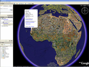 MODIS fires displayed on Google Earth. |
Diane Davies: In more remote areas, fire data delivered by FIRMS can often provide the first notification of a fire in a protected area. For example, the Baviaanskloof Conservation Area in South Africa is mountainous and the terrain ‘rather inaccessible’ — a conservationist there told us that due to “budget constraints and lack of technical capacity satellite applications have remained out of reach. But with the Web Fire Mapper that has changed.” In Riau, Sumatra, WWF use MODIS active fire data engage big companies who are logging illegally as part of their ‘Eyes on the Forest program.’ In Thailand FIRMS data is used to monitor and send alerts to all protected areas. In these, and other situations, data from FIRMS are used to trigger the deployment of often limited resources to investigate a fire. In 2007, in Belize and Indonesia, MODIS fire data provided by FIRMS and Conservation International prompted field investigations which led to the detection of illegal clearing within in two national parks.
In other situations, a protected area manager may have heard about a fire but perhaps not know its exact location — data from FIRMS can be used to provide a more precise locations and the geospatial context of the fire (i.e. which roads/settlements are close by). FIRMS also provides MODIS image subsets, or quick look images which allow users daily views of their area of interest — these have proved to be particularly useful for mapping burned areas in Kruger National Park, South Africa and for a range of protected areas in Botswana. On occasions, the MODIS quick look images have also been used to support strategic fire management as it enables managers to get a better understanding of what area has already burned and the direction and extent of smoke. FIRMS data are also used for helping determine fire policy and developing vegetation management strategies.
Mongabay: Is FIRMS being assessed for its relevance to REDD (Reducing Emissions from Deforestation and Degradation) monitoring?
Diane Davies: The success of REDD will depend on an ability to monitor forests and ensure they remain intact. As the REDD program become more widespread I think tools such as FIRMS and CI’s fire alert system will prove to be very useful — we know from experience that fires detected from satellite can indicate the presence of logging and clearing activities. Early warning of such fires will prove extremely useful when monitoring large areas.
Mongabay: What’s the long-term outlook for the satellites that carry the MODIS sensor? Is there any risk that funding cuts could affect the Terra and Aqua satellites? Are you likely to see improvements in resolution in the near future?
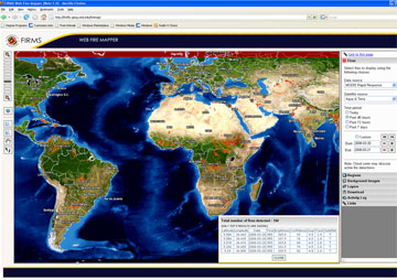 FIRMS web fire mapper
|
Diane Davies: All good questions! The MODIS (or Moderate Resolution Imaging Spectroradiometer) sensor onboard Terra and Aqua (Earth Observing Satellites) is a research, rather than operational sensor, which means NASA does not have plans to launch direct replacements. However a new operational sensor is being developed to extend the measurement series of the MODIS sensor beyond Terra and Aqua satellites. The replacement sensor, the Visible Imaging Infrared Radiometer Suite (VIIRS), is part of the National Polar-orbiting Operational Environmental Satellite System (NPOESS) Preparatory Project (NPP). NPP is scheduled to launch in fall 2009.
NPP (the NPOESS Prepratory Project) is a joint mission between NASA and the NPOESS Intergrated Program Office. NPP’s mission is to collect and distribute remotely sensed data for the land, ocean and atmosphere for meteorological and global climate change studies. It allows for the transition from Earth observing (EOS) missions carried out by satellites such as Terra and Aqua to NPOESS. NPP will provide data such as atmospheric and sea surface temperatures, humidity soundings, land and ocean biological productivity, and cloud and aerosol properties.
VIIRS will be similar to the MODIS sensor but will utilize more bands and more refined and advanced algorithms, resulting in greatly enhanced imaging and data collection. Through advances in technology and building upon sensors such as MODIS, SeaWiFS, POES’ Advanced Very High Resolution Radiometer (AVHRR) and DMSP’s Operational Linescan System (OLS), VIIRS is a smaller and less complicated sensor.
VIIRS will not provide improvements over the spatial resolution of MODIS. VIIRS uses a multi-spectral scanning radiometer with 12 bit quantization and measures 22 bands between 0.4 and 12 microns. The swath width is 3000 km. The imagery spatial resolution is 370 meters at nadir or 740 meters depending on the spectral band.
National Polar-orbiting Operational Environmental Satellite Systems:
