Global malaria map
Global malaria map released – 35% of humanity at risk
mongabay.com
February 25, 2008
|
|
Researchers have developed a spatial distribution map for malaria. The results are published in Public Library of Science (PLoS) Medicine.
The map shows that more than 2.3 billion people, or about 35 percent of the world’s population, live in areas where there is risk of a deadly form of malaria. Each year 500 million people suffer from malaria and about one million people, mostly children living in sub-Saharan Africa, die from the disease which is spread through bites from Anopheles mosquitoes infected with the Plasmodium falciparum parasite.
The map is based on “data on malaria cases, travel advisories, and surveys in several thousand communities across 87 countries,” according to a statement from PLoS. The map also incorporates “information about climatic conditions that affect the parasite’s life cycle and consequently the likelihood of active transmission. For example, below a certain temperature, infected mosquitoes reach the end of their natural life span before the parasite has had time to develop into a stage that can infect humans, which means that malaria transmission does not occur.”
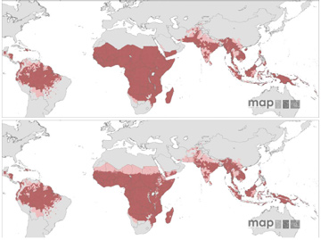 P. falciparum Malaria Risk Defined by Annual Parasite Incidence (top), Temperature, and Aridity (bottom). Areas were defined as stable (dark-red areas, where PfAPI, 0.1 per thousand pa), unstable (pink areas, where PfAPI , 0.1 per thousand pa), or no risk (light grey). Map from Guerra et al 2008 |
The researchers say the map will help guide campaigns to control the disease.
“The efficient allocation of financial resources for malaria control using appropriate combinations of interventions requires accurate information on the geographic distribution
of malaria risk. An evidence-based description of the global range of Plasmodium falciparum malaria and its endemicity has not been assembled in almost 40 [years],” write the authors. “This paper aims to define the global geographic distribution of P. falciparum malaria in 2007 and to provide a preliminary description of its transmission intensity within this range.”
“This new map is a plausible representation of the current extent of P. falciparum risk and the most contemporary summary of the population at risk of P. falciparum malaria within these limits,” they continue. “The release of this information in the public domain will help focus future resources for P. falciparum malaria control and elimination.”
Guerra CA, Gikandi PW, Tatem AJ, Noor AM, Smith DL, et al. (2008). The limits and intensity of Plasmodium falciparum transmission: Implications for malaria control and elimination worldwide. PLoS Med 5(2): e38