Arctic sea ice extent hits record low in September
Arctic sea ice extent hits record low in September
mongabay.com
October 16, 2007
|
|
Arctic sea ice reached a record low in September 2007, well below the previous record set in 2005 and substantially below the long-term average, according to an image released by NASA.
The announcement, based on satellite analysis showing sea ice concentration, comes weeks after the University of Illinois reported that sea ice area hit a record low and the Alfred-Wegener-Institute for Polar and Marine Research expedition to the North Polar Sea found that large areas of the Arctic sea ice are only half the thickness found in 2001. The findings all confirm that Arctic sea ice has declining rapidly and extensively.
The Arctic is particularly sensitive to changes in the extent of sea ice, which helps reflect sunlight back into space, cooling the region. When sea ice melts, the dark areas of open water absorb the sun’s radiation, trigger a positive feedback loop that worsens melting.
Earlier articles
Arctic sea ice melts to all-time record low (September 12, 2007) Sea ice cover in the Arctic Ocean is presently 20 percent below its all time lowest extent and may decline further before winter, said scientists from the National Snow and Ice Data Center in Boulder (NSIDC).
Northwest Passage now open for business (September 15, 2007) Melting sea ice has opened the Northwest Passage in the Arctic to navigation, reports the European Space Agency. The clearing allows direct access between the North Pacific and North Atlantic and could eventually be a cheaper shipping route that the Panama Canal.
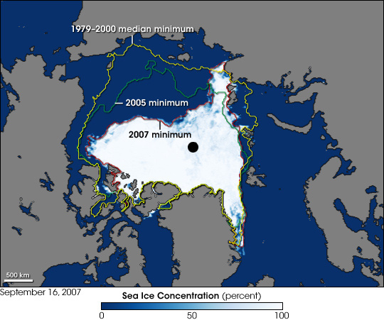
Three contour lines appear on this image. The red line is the 2007 minimum, as of September 15, about the same time the record low was reached, and it almost exactly fits the sea ice observed by the Advanced Microwave Scanning Radiometer for EOS (AMSR-E) aboard NASA’s Aqua satellite on September 16, 2007. The green line indicates the 2005 minimum, the previous record low. The yellow line indicates the median minimum from 1979 to 2000. NASA image created by Jesse Allen, using AMSR-E data courtesy of the National Snow and Ice Data Center (NSIDC), and sea ice extent contours courtesy of Terry Haran and Matt Savoie, NSIDC, based on Special Sensor Microwave Imager (SSM/I) data. |