2007 Amazon fires among worst ever
2007 Amazon fires among worst ever
Rhett A. Butler, mongabay.com
October 22, 2007
By some measures, forest fires in the Amazon are at near-record levels, according to analysis Brazilian satellite data by mongabay.com. A surge in soy and cattle prices may be contributing to an increase in deforestation since last year.
Last year environmentalists and the Brazilian government heralded a sharp fall in deforestation rates, the third consecutive annual decline after a peak in 2004. Forest loss in the 2006-2007 season was the lowest since record-keeping began in the late in 1970s. While the government tried to claim credit for the drop, analysts at the time said that commodity prices were a more likely driver of slow down: both cattle and soy prices had declined significantly over the previous months.
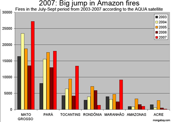
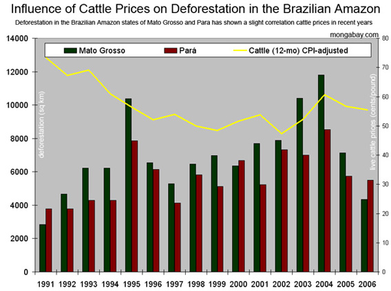
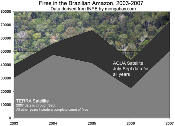
Now with prices of both commodities on the upswing, Brazilian satellite data show a marked increase in the number of fires and deforestation in the region. The states of Para and Mato Grosso — the heart of Brazil’s booming agricultural frontier — both experienced a 50 percent or more increase in forest loss over the same period last year coupled with a large jump in burning: a 39-85 percent jump in the number of fires in Para during the July-September burning period and 100-127 percent rise in Mato Grosso, depending on the satellite. More broadly, the 50,729 fires recorded by the Terra satellite and 72,329 measured by the AQUA satellite across the Brazilian Amazon are the highest on record based on available data going back to 2003 (the NMODIS-01D satellite suggests 2005 burning was higher but still shows a 54 percent jump since last year). Reports from the ground indicate that burning is indeed very bad this year.
|
“I have never seen fires this bad,” John Cain Carter, a rancher who runs the NGO Aliança da Terra, told mongabay.com. “The fires are even worse than in 1998´s El Niño event… A huge area of the Xingu National Park was on fire, truly sickening as it is a sign of things to come.”
Fires linked to roads
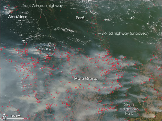
Satellite imagery from NASA indicates that much of the burning is concentrated around two major Amazon roads: Trans-Amazon highway in the state of Amazonas, and the unpaved portion of the BR-163 Highway in the state of Pará. Scientists have long warned that the roads would drive deforestation in the area by encouraging settlement and development.
Dr. Philip M. Fearnside, one of the most widely cited experts on the Amazon, says that the rise of soy in the region has provided support for infrastructure projects which, in turn, have fueled forest destruction.
“Soybean farms cause some forest clearing directly. But they have a much greater impact on deforestation by consuming cleared land, savanna, and transitional forests, thereby pushing ranchers and slash-and-burn farmers ever deeper into the forest frontier,” he explained after co-authoring a 2004 paper in Science on the impact of soy. “Soybean farming also provides a key economic and political impetus for new highways and infrastructure projects, which accelerate deforestation by other actors.”
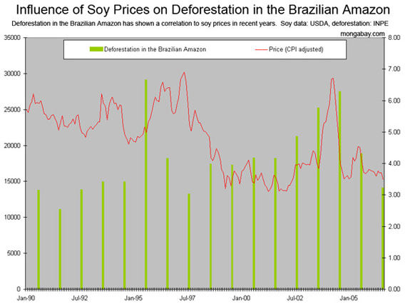
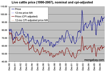
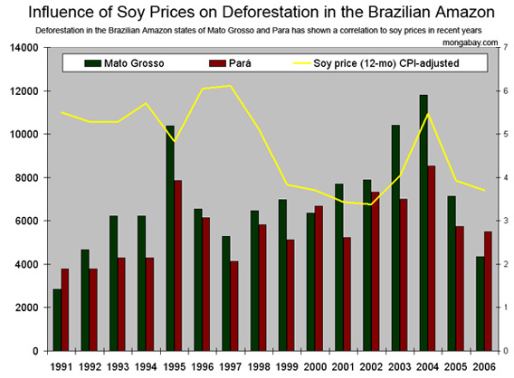 Influence of soy prices (CPI-adjusted, 12-month moving average) on deforestation in the Brazilian Amazon. Deforestation in the states of Mato Grosso and Para has shown a particularly strong correlation to soy prices in recent years. All figures in hectares (2.47 acres).
|
“What’s most striking is that fires in 2007 have increased dramatically in the main soy-production states in the Brazilian Amazon—Mato Grosso, Para, Maranhao, and Tocantins—but have dropped or remain stable in other Amazonian states,” said Dr. William Laurance, a senior researcher at the Smithsonian Tropical Research Institute (STRI) in Panama and another noted Amazon scientist. “Clearly, soy farming is becoming a major driver of land-use change in the Amazon. The international consumers of Brazilian soy need to understand its key role in driving Amazon deforestation”
Researchers have also expressed concern that conversion of forest to agricultural fields — in concert with fires and broader climate shifts — could affect rainfall in the Amazon, with significant impacts on the rainforest ecosystem.
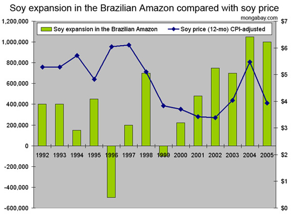
  Why the biofuels boom — corn ethanol in the U.S. and sugarcane ethanol in Brazil — is driving Amazon deforestation. Growing demand for corn ethanol means that more corn and less soy is being planted in the United States. Brazil is more than making up for shortfall by clearing new land for soy cultivation. While only a fraction of this cultivation currently occurs in the Amazon rainforest, production in neighboring areas like the cerrado grassland helps drive deforestation by displacing small farmers and cattle producers, who then clear rainforest land for subsistence agriculture and pasture. A similar trend is occurring with sugarcane plantations in eastern Brazil. U.S. ethanol may drive Amazon deforestation |
“There are several other factors that are pushing the Amazon towards a drier future, including fresh evidence that cattle ranches and pastures are less capable of generating rain than the forests they replace because they put less water vapor into the air–soy fields are even worse,” Dr. Daniel Nepstad, head of the Woods Hole Research Center’s Amazon program, told mongabay.com. “On top of these changes in the vegetation itself we have rainfall-inhibiting smoke and the prospect of sea temperature changes–not just el Niño which we have always known creates drought in the Amazon–but the North Atlantic tropical anomaly like we saw in 2005 when we had record drought and record fires in the Amazon. The likelihood of that type of anomaly will increase with global warming. If we start to see sea surface temperature anomalies more frequently–either el Niño or the warming of the tropical North Atlantic (that occurred in 2005)–then the area of tropical forest that burns could explode. ”
“The nightmare scenario is one where we have a 2005-like year that extended for a couple years, coupled with a high deforestation where we get huge areas of burning, which would produce smoke that would further reduce rainfall, worsening the cycle,” he continued. “A situation like this is very possible. While some climate modelers point to the end of the century for such a scenario, our own field evidence coupled with aggregated modeling suggests there could be such a dieback within two decades.”
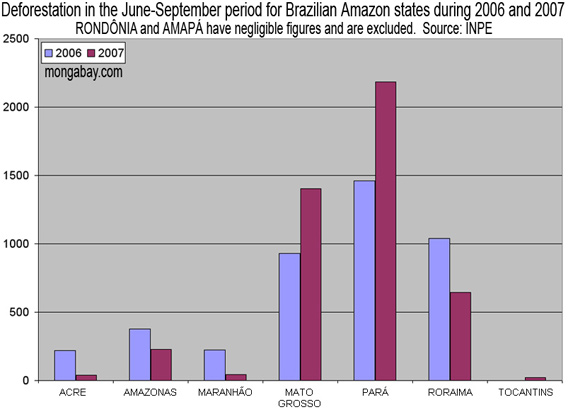 June-September deforestation in Brazilian Amazon states, 2006 versus 2007. Note that Rondônia and Amapá are excluded due to low forest loss in each year. Source: INPE
|
While the latest satellite images depict a raging inferno across much of the Amazon, the states of Acre, Amazonas and Rondônia show a decline in the number of fires, over the same period last year. Further, forest loss during the 2007 June-September burning season is not keeping pace with the overall number of fires, suggesting that many are burning in already deforested areas and agricultural zones. In total, deforestation during the June to September period rose from 4,250 square kilometers in 2006 to 4,570 square kilometers this year, an increase of 8 percent.
“Substantial increases of the order of above 600% were observed in Rondônia. Para and Mato Grosso also show significant increases in every month except July. And in general compared the results show an increase of 8% between 2006 and 2007,” said Dalton Valeriano who runs the Brazilian National Institute of Space Research (INPE) deforestation monitoring program known as DETER.
|