Failing water supplies destroyed Angkor Wat in Cambodia
Failing water supply destroyed lost city of Angkor Wat
Ancient city, one of the largest ever known, done in by environmental degradation
mongabay.com
August 13, 2007
Deforestation may have lead to the demise of one of the world’s most extensive preindustrial settlements
The ancient city of Angkor in Cambodia was larger in extent than previously thought and fed by a single water system, according to a new map published by an international team of researchers. The study, published in the early online edition of the journal Proceedings of the Natural Academy of Sciences, suggests that the urban settlement sustained an elaborate water management network extending over more than 1,0000 square kilometers.
Analyzing hand-drawn maps, ground surveys, airborne photography, and ground-sensing radar provided by NASA, archeologist Damian Evans of the University of Sydney and colleagues identified over a thousand previously unknown manmade ponds and at least 74 long-lost temples. The research shows that Angkor was sustained by a single hydraulic system which delivered a stable water supply to the network despite unpredictable monsoon rains.
“Even on a quite conservative estimate, Greater Angkor, at its peak, was therefore the world’s most extensive preindustrial low density urban complex,” wrote the authors. “The scale of the urban complex also has implications for its history and its demise.”

Bayon/Angkor Thom in Cambodia. Photo by Rhett A. Butler. |
The research supports the theory that the “overexploitation of the landscape” eventually led to the collapse of Angkor.
“Angkor stands in a vast expanse of rice fields that would have required extensive forest clearance over the entire Angkor plain and up into the Kulen and Khror hills to the north. The new maps show that land-use modification at Angkor was both extensive and substantial enough to have produced a number of very serious ecological problems, including deforestation, overpopulation, topsoil degradation, and erosion,” wrote the authors. “Whatever the functions of the infrastructural network, the impact of extensive clearance for rice fields, the economic and demographic consequences of constant modifications to the landscape, and unpredictable events such as flooding or warfare would potentially have been extremely serious for such an elaborate and interlinked system.”
Evans and colleagues say that Angkor’s demise could provide insight on the collapse of other ancient urban settlements, many of which are still poorly known, obscured by vegetation or modern settlements.
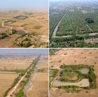
Oblique aerial views of remnant Angkorian urban features. (Upper Left) Occupation mounds and ponds. (Upper Right) Canals and embankments. (Lower Left) Multifunction roadway/canals. (Lower Right) Classic village temple” configuration. Images courtesy of PNAS. |
“The key sites to be examined in southern Asia include Pagan in Myanmar, Anuradhapura and Pollonuruwa in Sri Lanka, Borobudur and Prambanan in Indonesia, Sukhothai in Thailand, Sambor Prei Kuk and Koh Ker in Cambodia, and My Son in Vietnam,” they continue. “Although there may prove to be no substantial occupation around the monuments at these sites, further analysis is critical, because similar discoveries in these locations would transform our understanding of their social, cultural, and environmental contexts in much the same way as has happened for the Maya settlements and now for Angkor. This, in turn, will provide a foundation for comparative studies of the great cities that emerged and then collapsed in fragile tropical ecosystems, an important and topical field of research that has received minimal attention thus far.”
CITATION: Damian Evans, Christophe Pottier, Roland Fletcher, Scott Hensley, Ian Tapley, Anthony Milne, and Michael Barbetti (2007). A new archaeological map of the world’s largest pre-industrial settlement complex at Angkor, Cambodia.