NASA maps newly proposed source of the Amazon River
NASA maps newly proposed source of the Amazon River
mongabay.com
July 3, 2007
NASA released a map showing the newly proposed source of the Amazon River, a change that would make it the longest river in the world.
Last month Brazilian researchers proposed Mount Mismi, a snow-covered mountain in southern Peru as the source of the Amazon River. Previously, the generally accepted source was in northern Peru.
If the revision holds, the length of the Amazon would exceed that of the Nile by roughly 60 miles (105 km). However the claim is likely to be contested.
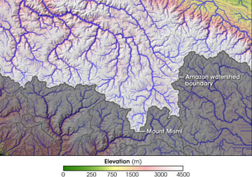
Without taking a position on the issue, NASA posted a digital map of water channels to show the location of the newly claimed source. The map is the result of the HydroSHEDS project derived from NASA’s Shuttle Radar Topography Mission in 2000.
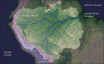
The space agency describes the map as follows: “For clarity, the Amazon Basin and the watersheds feeding it appear bright, while the surrounding area appears darker. A white box outlines the region that the Brazilian researchers identified as the Amazon’s source; that area is enlarged in the bottom image. The larger image shows the rim of higher terrain along the western edge of the Amazon, where tributaries drain off mountain peaks in the Andes. A complicated network of riverbeds appears around Mount Mismi.” |
Guido Gelli, director of science at the Brazilian Institute of Geography and Statistics which co-sponsored the research with the National Geographical Institute of Peru, told BBC News that the Amazon now appears to be 6,800 kilometers (4,250 miles) long. The Nile is believed to be 6,695 kilometers (4,160 miles) long. The length of the Amazon is usually listed at 3,969 miles (6,387 km).
While the new claims will be debated, there is no doubt that the Amazon is the world’s largest river. Its volume is greater than that of the next eight largest rivers combined.
Climate concerns
Tracing the origin of the Amazon river back to a glacier highlights the vulnerability of the river system to climate change. Glaciers and snowmelt in the Andes are the source for as much as 50 percent of the water in the upper Amazon, yet global warming puts these at risk: the Peruvian government estimates that the country’s glaciers have shrunk by more than 20% in the past 30 years and could disappear in the next 40. Further downstream, models show that climate change, combined with deforestation, will leave the Amazon rainforest considerably drier by 2050, further impacting water availability in the river basin.