NASA images show expansion of logging in Congo rainforest
NASA images show expansion of logging in Congo rainforest
mongabay.com
July 15, 2007
New high resolution images of logging roads in the Congo region of Africa are helping researchers understand the expansion of industrial logging in Central Africa.
Using highly detailed images from NASA and commercial satellite firms, scientists from the Woods Hole Research Center (WHRC) created a map of logging roads and forest disturbance across 4 million square kilometers of tropical African forests between 1976 and 2003.
The researchers found that Northern Congo experienced the largest increase in roads during the period; road construction increased from a 1976-1990 average of 156 kilometers per year to over 660 kilometers per year after 2000. By 2003, logging roads account for more than 60 percent of the length of all roads in Congo.
“Roads provide access, and this research provides clear evidence that the rainforests of Central Africa are not as remote as they once were”.a bad thing for many of the species that call it home,” said Jared Stabach, a WHRC scientist and a co-author of a paper, published June 8 in Science, detailing the research: Logging roads rapidly expanding in Congo rainforest.
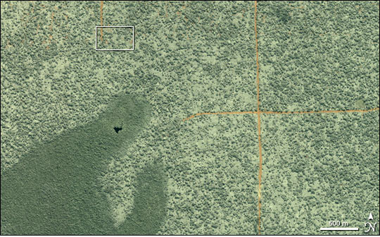 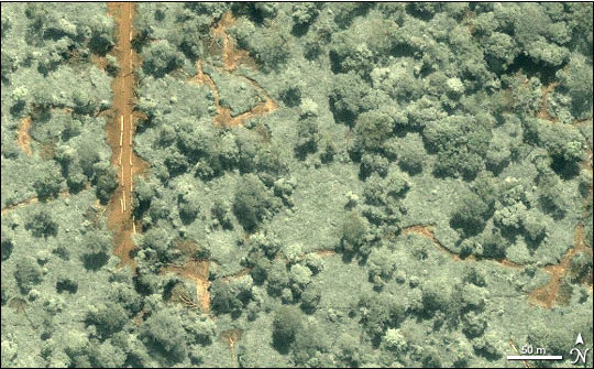 This very high resolution image of northern Republic of Congo was captured on June 27, 2002, by the commercial satellite Ikonos. The wider-area view at top shows dirt logging roads (orange lines) and different types of forest in the area around the border of the Sangha and Likouala regions. The lower view is a close-up image that shows not only part of a logging road, but also felling sites (clearings where trees are cut down) and skid trails (paths where trees are dragged toward the road.) Individual trees or sections of trees stacked on the road at left look like matchsticks. Two types of forest are shown in the top image. At bottom left is a tropical evergreen forest with an extremely dense canopy, a forest type known locally as limbali forest. Most of the rest of the scene is occupied by a more open forest in which stands of trees (dark green patches) are separated from each other by a sea of lower-growing plants (light green). The appearance of openness, however, is something of an illusion. A dense understory of plants, such as wild ginger that can grow to be 2 meters (about 6.5 feet) tall, makes a thicket so impenetrable that you could not walk through it without a machete. Shadows along the margins of skid trails hint at the thickness and height of the understory. (Scientists are not certain how this type of forest originated, but the wide spacing of the trees is not a result of recent logging activity). NASA image created by Jesse Allen, using IKONOS data provided courtesy of Nadine Laporte, Woods Hole Research Center. Caption text courtesy of NASA. |
Logging roads rapidly expanding in Congo rainforest.
Logging roads are rapidly expanding in the Congo rainforest, report researchers who have constructed the first satellite-based maps of road construction in Central Africa. The authors say the work will help conservation agencies, governments, and scientists better understand how the expansion of logging is impacting the forest, its inhabitants, and global climate.