2007 hurricane season will be “very active” but not due to global warming
Rhett A. Butler, mongabay.com
April 3, 2007
Developing La Nina conditions, not global warming, should make the 2007 Atlantic hurricane season “very active,” according to a top U.S. hurricane forecaster.
William Gray of the Department of Atmospheric Science at Colorado State University said he expects 17 named storms this year, including 9 hurricanes. He says there is a 74 percent chance that a category 3, 4, or 5 hurricane will hit the U.S. coastline (the historic average for the past century is 52 percent) and a 49 percent chance that such a storm would hit the Gulf Coast of the United States (versus an average of 30 percent for the past century).
“There were five hurricane seasons since 1949 with characteristics most similar to what we observe in February-March 2007 and characteristics that we expect to see in August-October 2007,” wrote Gray and his colleagues Philip J. Klotzbach and William Thorson. “The best analog years that we could find for the 2007 hurricane season are 1952, 1964, 1966, 1995 and 2003. We anticipate that 2007 seasonal hurricane activity will have activity slightly more than what was experienced in the average of these five years. We expect the 2007 hurricane season to be very active.”
Gray says that last year’s forecasts, which predicted above average hurricane activity, were usurped by the weak to moderate El Niño event, a phenomenon that reduces Atlantic basin hurricanes. This year El Niño conditions have subsided, meaning that hurricane activity is likely to return.
He adds that the recent upswing in hurricanes is likely a result of naturally occurring multi-decadal Atlantic Ocean circulation variations, not global warming.

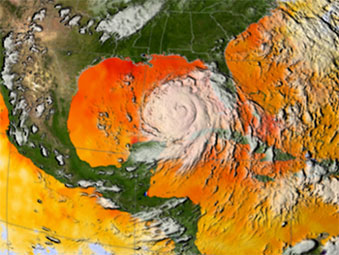
Warm ocean waters fuel hurricanes, and there was plenty of warm water for Katrina to build up strength once she crossed over Florida and moved into the Gulf of Mexico. This image depicts a 3-day average of actual sea surface temperatures (SSTs) for the Caribbean Sea and the Atlantic Ocean, from August 25-27, 2005. Every area in yellow, orange or red represents 82 degrees Fahrenheit or above. A hurricane needs SSTs at 82 degrees or warmer to strengthen. The data came from the Advanced Microwave Scanning Radiometer (AMSR-E) instrument on NASA’s Aqua satellite. The GOES satellite provided the cloud data for this image. Image Credit: NASA/SVS. |
“The Atlantic has seen a very large increase in major hurricanes during the 12-year period of 1995-2006 (average 3.9 per year) in comparison to the prior 25-year period of 1970-1994 (average 1.5 per year). This large increase in Atlantic major hurricanes is primarily a result of the multi-decadal increase in the Atlantic Ocean thermohaline circulation (THC) that is not directly related to global temperature increase or to human-induced greenhouse gas increases. Changes in ocean salinity are believed to be the driving mechanism. These multi-decadal changes have also been termed the Atlantic Multidecadal Oscillation (AMO).”
Gray notes that hurricane activity in the past 12 years appears to be similar to that of the 1940s and 1950s.
“There have been similar past periods (1940s-1950s) when the Atlantic was just as active as in recent years. For instance, when we compare Atlantic basin hurricane numbers over the 15-year period (1990-2004) with an earlier 15-year period (1950-1964), we see no difference in hurricane frequency or intensity even though the global surface temperatures were cooler and there was a general global cooling during 1950-1964 as compared with global warming during 1990-2004.”
He says that the small changes is sea surface temperature recorded to date would not likely trigger an increase in the number of intensity of hurricanes.
Related articles


