Satellite imagery to be used to detect illegal logging, determine sustainability
Satellite imagery to be used to detect illegal logging, determine sustainability
mongabay.com
December 21, 2006
New types of satellite imagery to be used to detect illegal logging and help determine sustainability in remote forests.
A new project aims to use advanced satellite imagery to monitor illegal logging activities and help certify the sustainability of timber harvesting in some of the world’s most remote forests. The effort could reduce the cost of forest management and certification, while helping to crack down on illicit tree-felling.
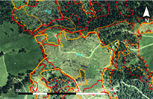 Mapping of forest damages using aerial photograph. Courtesy of Eyre Consulting |
The Forest Stewardship Council, the international standard setting organization for responsible forest management, has teamed up with the European Space Agency (ESA), Aon, Eyre Consulting, Sarmap and Ambiental Technical Solutions on the project which will develop remote sensing and Geographic Information System (GIS) services. Three FSC-certified forestry companies, Global Forest Products (South Africa), CIB (Republic of Congo) and Orsa Group (Brazil) will participate in the trials, which will run through 2007.
Charles Crosthwaite Eyre, project manager for Aon, says that improvements in remote sensing technology, including higher resolution imagery, have expanded the capabilities of remote forest monitoring.
“New developments in remote sensing technology mean that a new breed of satellite, able to see through clouds and provide detailed imagery of forestry activities on the ground, can provide information the forestry sector needs to meet the sustainability challenges of the 21st Century – including the monitoring of illegal logging activities and deforestation,” he said.
Mr. Eyre says that the project will also evaluate the remote sensing technology in relation to the FSC principles and criteria on sustainable forest management, to see if these can help to evaluate if the criteria are being met by foresters on the ground. For example, forest companies and the FSC will evaluate whether the remote sensing technologies can help pinpoint illegal logging activities and road construction, identify selected tree species in a diverse forest landscape, assess timber volume, and support monitoring of plantations for pest attack.
Given the growing demand for FSC-certified wood products and mounting concerns over losses from illegal logging — estimated by the World Bank to cost tropical countries some $15 billion in lost revenue and economic damage per year — new types of remote sensing technology such as those used in this project will be of great value if they can contribute to forest management and the certification process by rapidly accessing high-quality and low cost geospatial information.
“Our objective is to prove this technology can support the certification process and help better understand, monitor and manage forest resources,” said Mr. Eyre.