Ozone hole near record size
Ozone loss hits record in 2006
mongabay.com
October 2, 2006
The European Space Agency (ESA) said that ozone loss in Antarctica hit a record in 2006. ESA reports that ozone measurements made by the Envisat satellite showed the ozone loss of 40 million tons of ozone, a level exceeding the previous record ozone loss of about 39 million tonnes for 2000.
ESA’s announcement comes a little more than a week after the World Meteorological Organization (WMO) reported that hole in the ozone layer over Antarctica will expand this year to 27.9 million square kilometers (10.8 million square miles), its second-highest recorded level in history.
ESA notes the difference between “ozone loss” is measured by the area and the depth of the ozone hole.
The hole results from the “catalytic destruction” of ozone by atomic chlorine and bromine, the source of which is primarily chlorofluorocarbon (CFC) compounds known as “freons” and bromofluorocarbon compounds known as Halons. In 1987, following the discovery that these compounds were responsible for the ozone depletion in the upper atmosphere, the international community adopted the Montreal Protocol which banned the production of CFCs and halons as well as related ozone depleting chemicals.
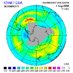 2006 ozone hole as measured by the SCIAMACHY instrument onboard Envisat. Credits: KNMI/TEMIS.
|
Because the ozone layer prevents most harmful UVB wavelengths of ultraviolet light from entering the Earth’s atmosphere, ozone depletion is a significant concern. Increased penetration by UVB wavelengths of ultraviolet light is believed to heighten the incidence of skin cancer, damage plants, and reduce ocean plankton populations.
Scientists from NASA and other agencies believe that the ozone hole over the Antarctic will recover around 2068, nearly 20 years later than estimated in the late 1990s.
A news release from the agency appears below.
Record ozone loss during 2006 over South Pole
October 2, 2006
Ozone measurements made by ESA’s Envisat satellite have revealed the ozone loss of 40 million tonnes on 2 October 2006 has exceeded the record ozone loss of about 39 million tonnes for 2000.
Ozone loss is derived by measuring the area and the depth of the ozone hole. The size of this year’s ozone hole is 28 million square km, nearly as large as the record ozone hole extension during 2000, and the depth of the ozone hole is around 100 Dobson Units, rivalling the record low ozone values in 1998. This year’s record ozone loss was reached because these two measurements occurred during the same time period. (A Dobson unit is a unit of measurement that describes the thickness of the ozone layer in a column directly above the location being measured.)
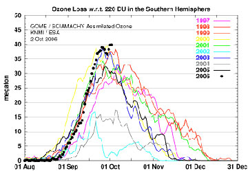 The ozone loss at 12:00 GMT of each day from GOME (1996-2002) and SCIAMACHY (2003-2006) Assimilated Ozone Fields. The ozone loss is the amount of ozone in megaton necessary to fill the ozone hole to 220 Dobson units (DU) over the whole area. DU stands for the total thickness of ozone in a given vertical column if it were concentrated into a single slab at standard temperature and atmospheric pressure — 400 DUs is equivalent to a thickness of four millimetres, for example. Credits: KNMI/TEMIS 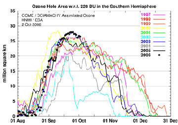 The size of the Antarctic ozone hole at 12:00 GMT of each day from GOME (1996-2002) and SCIAMACHY (2003-2006) Assimilated Ozone Fields. The size of the ozone hole is the area on the globe in million square km of ozone column values below 220 Dobson units (DU). DU stands for the total thickness of ozone in a given vertical column if it were concentrated into a single slab at standard temperature and atmospheric pressure — 400 DUs is equivalent to a thickness of four millimetres, for example. Credits: KNMI/TEMIS |
“Such significant ozone loss requires very low temperatures in the stratosphere combined with sunlight. This year’s extreme loss of ozone can be explained by the temperatures above Antarctica reaching the lowest recorded in the area since 1979,” ESA Atmospheric Engineer Claus Zehner said.
Ozone is a protective layer found about 25 kilometres above us mostly in the stratospheric stratum of the atmosphere that acts as a sunlight filter shielding life on Earth from harmful ultraviolet rays. Over the last decade the ozone level has lowered by about 0.3% per year on a global scale, increasing the risk of skin cancer, cataracts and harm to marine life.
The thinning of the ozone is caused by the presence of pollutants in the atmosphere such as chlorine, originating from man-made pollutants like chlorofluorocarbons (CFCs), which have still not vanished from the air despite being banned under the Montreal Protocol (1987).
During the southern hemisphere winter, the atmospheric mass above the Antarctic continent is kept cut off from exchanges with mid-latitude air by prevailing winds known as the polar vortex. This leads to very low temperatures, and in the cold and continuous darkness of this season, polar stratospheric clouds are formed that contain chlorine.
As the polar spring arrives, the combination of returning sunlight and the presence of polar stratospheric clouds leads to splitting of chlorine compounds into highly ozone-reactive radicals that break ozone down into individual oxygen molecules. A single molecule of chlorine has the potential to break down thousands of molecules of ozone.
The ozone hole, first recognised in 1985, typically persists until November or December, when the winds surrounding the South Pole (polar vortex) weaken, and ozone-poor air inside the vortex is mixed with ozone-rich air outside it.
Envisat, the largest Earth observation satellite ever built, can localise ozone depletion and track its changes, enabling the rapid estimation of UV radiation as well as providing forecasting. The three atmospheric instruments aboard Envisat are the Scanning Imaging Absorption Spectrometer for Atmospheric Cartography (SCIAMACHY), the global ozone monitoring by occultation of stars (GOMOS) sensor and the Michelson interferometer for passive atmospheric sounding (MIPAS).
In the framework of GMES (Global Monitoring of the Environment and Security), ESA has backed a project named TEMIS (Tropospheric Emission Monitoring Internet Service) that provides operational ozone and UV radiation monitoring based on SCIAMACHY and GOME-1 data. The ozone-monitoring data provided by these instruments span a time period of 11 years, which will be extended by the upcoming MetOp satellite series.
The first MetOp satellite in the series of three is scheduled to be launched in 2006 and will assist climate researchers in monitoring ozone levels and other atmospheric parameters. MetOp — Europe’s first polar-orbiting satellite and a mission dedicated to operational meteorology — will include a next-generation ozone-monitoring instrument called GOME-2, intended to guarantee continuity of observation of this vital environmental factor well into the following decades.
“Long-term measurements of ozone levels are of key importance for being able to monitor the ozone’s predicted recovery, which is currently estimated to take place by around 2060,” Zehner said.
This is article used information from Wikipedia and previous mongabay.com articles and includes a news release from ESA.