Greenland’s ice melting rapidly
Greenland’s ice melting rapidly
University of Texas at Austin
August 10, 2006
A new analysis of data from twin satellites has revealed that the melting of Greenland’s ice sheet has increased dramatically in the past few years, with much of the loss occurring primarily along one shoreline potentially affecting weather in Western Europe.
The loss of ice has been occurring about five times faster from Greenland’s southeastern region in the past two years than in the previous year and a half. The dramatic changes were documented during a University of Texas at Austin study of Greenland’s mass between 2002 and 2005.
The study was published today in the journal Science. Related results on the significant loss of ice from Antarctica were published in Science in March by other researchers participating in the Gravity Recovery and Climate Experiment (GRACE) mission. The GRACE mission is funded by NASA and the German Aerospace Center, and led by Aerospace Engineering Professor Byron Tapley at the university.
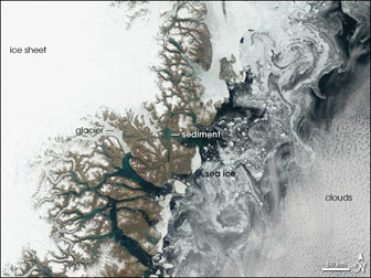 Greenland’s coast is riddled with fjords—glacier-carved canyons flooded by seawater. In several of the fjords, the water appears pale turquoise, in contrast to the dark blue of the ocean water. This lighter shade results from fine sediment. The sediment particles are small enough to remain suspended in water, lightening its color. East of the network of fjords, pale blue sea ice swirls along Greenland’s coast in a paisley pattern. These intricate shapes in the sea ice result from ocean currents moving in opposite directions. Immediately east of the coast is a southward current. East of that, a different ocean current heads north. The currents brushing past each other constantly push the sea ice in different directions. NASA image created by Jesse Allen, Earth Observatory, using data obtained from the Goddard Earth Sciences DAAC.  Aerospace Engineering Professor Dr. Byron Tapley, director of the Center for Space Research at The University of Texas at Austin, leads the Gravity Recovery and Climate Experiment (GRACE) mission. According to new analyses from the twin satellites that measure global mass changes, melting of Greenland’s ice sheet has increased dramatically in the past few years. The GRACE results were published in the Aug. 10 issue of Science. Photo by Patrick Cummings RELATED ARTICLES Antarctic and Greenland ice sheets are melting find new studies Scientists have confirmed that climate warming is changing how much water remains locked in the Antarctic and Greenland ice sheets, according to an article published in the Journal of Glaciology. Sea levels to rise 20 feet if ice melting trend continues New research says if current warming trends continue, the Greenland and Antarctic ice sheets are on track to melt sooner than previously thought, leading to a global sea level rise of at least 20 feet. Greenlanders looking forward to global warming Some people in Greenland are looking forward to climate change according to an article in today’s issue of The Wall Steet Journal. In “For Icy Greenland, Global Warming Has a Bright Side”, journalist Lauren Etter finds examples of global warming-induced changes that could benefit Greenlanders. She notes that the 2.7 degrees Fahrenheit rise in temperatures over the past 30 years has extended the growing season by two weeks while melting glaciers have exposed land for grazing and warmer seas enable fishermen to catch warm-water cod. |
“Our latest GRACE findings are the most complete measurement of ice mass loss for Greenland,” said Tapley, director of the university’s Center for Space Research (CSR) and holder of the Clare Cockrell Williams Centennial Chair in Engineering. “The sobering thing to see is that the whole process of glacial melting is stepping up much more rapidly than before.”
Antarctica is considered the largest, and Greenland the second largest, reservoir of fresh water on Earth, with the latter containing about 10 percent of the world’s fresh water. Melting of ice from these two regions is expected to impact sea level and ocean circulation, and potentially the future of climates worldwide.
The Greenland study, for example, suggests that the amount of fresh water contributed from the melting of its ice sheet could add 0.56 millimeters annually to a global increase in sea levels, higher than all previously published measurements.
“These findings are consistent with the most recent independent measurements of Greenland’s mass done by other techniques like satellite radar interferometry, but in this case they provide a direct measure of ice-mass changes,” said Geology Professor Clark Wilson, a co-author on the latest Science article who helped analyze the estimates for Greenland. Wilson chairs the Department of Geological Sciences at the university and holds the Wallace E. Pratt Professorship in Geophysics.
Within the subpolar zone that includes Greenland, the rapid rise in meltwater along its eastern coast could add to other warming-related factors believed to be weakening the counterclockwise flow of the North Atlantic Current. For instance, the increased meltwater could change how more buoyant fresh water mixes with salt water in a branch of this flow called the Norwegian Current. This change could lower the temperatures of water, and thus wind, that travels past the west coast of Ireland and Great Britain.
That ocean temperature change would occur because the current might not move northward past Norway before returning to more southerly latitudes. Warmer, southerly waters would be stalled from moving northward if that happened, resulting in chillier winters in parts of Western Europe.
“If enough fresh water enters the Norwegian Current,” Tapley said, “and you interrupt return flow, then there could be climate effects in Europe.”
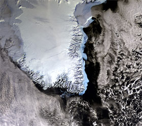 This image of South Greenland was acquired on 16 February 2006 by Envisat’s Medium Resolution Imaging Spectrometer (MERIS), working in Reduced Resolution mode. Credits: ESA |
The twin GRACE satellites provide the most comprehensive monthly estimates of Greenland’s ice-mass balance The satellites are sensitive to the gravitational pull of mass changes on Earth, which produce micrometer-scale variations in the distance (137 miles or 220 kilometers) that separates the two satellites as they fly in formation over Earth.
Lead author Jianli Chen, a CSR research scientist, developed a method to improve the effective spatial resolution of mass change estimates. The method used the known locations of major glaciers as information in estimating the sources of mass change.
“By using this special filtering procedure,” Chen said, “we teased out additional details of mass changes in Greenland along its Southeastern and Northeastern shores separately.”
The estimates showed that 69 percent of the ice-mass loss in recent years came from eastern Greenland. Of the 57 cubic miles (239 cubic kilometers) of water mass lost on average each year, 39 cubic miles (164 cubic kilometers) were from the eastern shoreline. More than half of that eastern loss involved ice from the glacier complex in southeast Greenland.
“This melting process may be approaching a point where it won’t be centuries before Greenland’s ice melts, but a much shorter time-frame,” Tapley said, noting that it isn’t possible to tell how much sooner this will be.
Tapley in the College of Engineering, and Wilson, whose department is part of the Jackson School of Geosciences, lead grants funded primarily by NASA to pursue research questions related to large-scale mass changes impacting Earth’s features.
This is a modified news release, “Greenland’s ice loss accelerating rapidly, gravity-measuring satellites reveal”, from The University of Texas at Austin.