NASA to study how African winds and dust influence hurricanes
NASA to study how African winds and dust influence hurricanes
NASA
July 31, 2006
Scientists from NASA, the National Oceanic and Atmospheric Administration, universities and international agencies will study how winds and dust conditions from Africa influence the birth of hurricanes in the Atlantic Ocean.
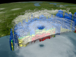
The NAMMA mission will also include the use of satellite data. This is an image of Hurricane Katrina on Sunday, August 28, 2005 at 5:30 PM EDT (21:33 UTC) as seen by the Tropical Rainfall Measuring Mission (TRMM) satellite’s PR (Precipitation Radar), VIRS (Visible Infrared Scanner), TMI (Tropical Microwave Imager) and the GOES spacecraft. TRMM looks underneath of the storm’s clouds to reveal the underlying rain structure. Blue represents areas with at least 0.25 inches of rain per hour. Green shows at least 0.5 inches of rain per hour. Yellow is at least 1.0 inches of rain and red is at least 2.0 inches of rain per hour. TRMM is a joint mission between NASA and the Japan Aerospace Exploration Agency (JAXA). Credit: NASA/JAXA 2006: Expect another big hurricane year says NOAA The 2006 hurricane season in the north Atlantic region is likely to again be very active, although less so than 2005 when a record-setting 15 hurricanes occurred, according to the National Oceanic and Atmospheric Administration (NOAA). |
The field campaign, called NASA African Monsoon Multidisciplinary Analyses 2006, runs from Aug. 15 to mid-September in the Cape Verde Islands, 350 miles off the coast of Senegal in West Africa. This campaign is a component of a much broader international project, called the African Monsoon Multidisciplinary Analyses, aimed at improving the knowledge and understanding of the West African Monsoon.
Researchers will use satellite data, weather station information, computer models and aircraft to provide scientists with better insight into all the conditions that enhance the development of tropical cyclones, the general name given to tropical depressions, storms and hurricanes. This research will help hurricane forecasters better understand the behavior of these deadly storms.
“Scientists recognize the hurricane development process when they see it, but our skill in forecasting which weak system will intensify into a major cyclone is not great,” said Edward Zipser, mission chief scientist, of the University of Utah, Salt Lake City. “That is why NASA and its partners place a high priority on obtaining high-quality data for weak disturbances, as well as those already showing signs of intensification.”
For hurricanes to develop, specific environmental conditions must be present: warm ocean waters, high humidity and favorable atmospheric and upward spiraling wind patterns off the ocean surface. Atlantic hurricanes usually start as weak tropical disturbances off the coast of West Africa and intensify into rotating storms with weak winds, called tropical depressions. If the depression continues to intensify and reaches wind speeds of at least 39 mph, they are classified as tropical storms. Hurricanes have winds greater than 73 mph.
To study these environmental conditions, researchers will use NASA’s DC-8 research aircraft as a platform for advanced atmospheric research instruments. Remote and on-site sensing devices will allow scientists to target specific areas in developing storms. Sensors on-board the aircraft will measure cloud and particle sizes and shapes, wind speed and direction, rainfall rates, atmospheric temperature, pressure and relative humidity.
The campaign will use extensive data from NASA’s fleet of earth observing satellites, including the Tropical Rainfall Measurement Mission, QuikSCAT, Aqua, and the recently-launched Cloudsat and CALIPSO. These advanced satellites will provide unprecedented views into the vertical structure of the tropical systems, while the field observations will help validate data from the new satellites.
To better understand the physics of hurricanes, researchers are seeking answers to questions about hurricane development, air currents and the effects of dust on clouds.
During the field campaign, scientists hope to get a better understanding of the role of the Saharan Air Layer and how its dry air, strong embedded winds and dust influences cyclone development. The layer is a mass of very dry, often dusty air that forms over the Sahara Desert during the late spring, summer, and early fall and usually moves out over the tropical Atlantic Ocean.
As part of looking at the Saharan Air Layer, scientists want to better understand dust’s effect on clouds. Some evidence indicates that dust makes it more difficult for rain to form. Cloud models need to account for any such effect, so measurements of cloud droplet concentrations and size in clean ocean air and dusty air from the Sahara need to be made.
This is a modified NASA news release