Map projects regional population growth for 2025
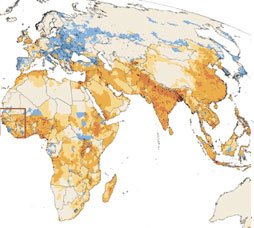 A section of the new population map created by the Center for Climate Systems Research shows increasing populations in coastal areas, which will expose 2.75 billion people worldwide to the effects of sea level rise and other coastal threats posed by global warming. Image courtesy of the Center for Climate Systems Research of The Earth Institute at Columbia University. |
Map projects regional population growth for 2025
Climate change may have an impact
mongabay.com
July 18, 2006
The number of people living within 60 miles (100 km) of a coastline is “expected to increase by 35 percent over 1995 population levels, exposing 2.75 billion people worldwide to the effects of sea level rise and other coastal threats posed by global warming,” according to a new map showing projected population change for the year 2025.
The map, developed by researchers at the Center for Climate Systems Research, a part of The Earth Institute at Columbia University in New York, and Population Action International, a Washington, D.C-based non-profit research and advocacy group, shows “that the greatest increases in population density through 2025 are likely to occur in areas of developing countries that are already quite densely populated,” according to a release from The Earth Institute.
The map further projects significant population decline in much of southern and Eastern Europe and Japan, smaller declines in population for “many regions in which they might be least expected: sub-Saharan Africa, Central and South America, the Philippines, Nepal, Turkey, Cambodia, Burma and Indonesia — areas that have to date been experiencing rapid-to-modest national population growth.”
“By bridging these two areas of demography — mapping and long-range, aggregate projections — we’re getting a better idea of where people are likely to live in the future and why,” said Stuart Gaffin, associate research scientist at the Center for Climate Systems Research and lead scientist on the project. “Hopefully, work like ours will play a central role in improving environmental policies around the world and in reducing natural hazard risks faced by the most vulnerable parts of society.”
The “Mapping the Future” map is unique in that unlike other projections that show future global population on a country-by-country basis, the work “displays the projected population for each of nine million cells distributed across the globe.” The map is useful to researchers needing to know where people are expected to live in the future. It can also be used to help forecast what populations might be at greatest risk from future natural disasters and the regions that will likely face water scarcity and resource shortages in the future.
“We already have a pretty good idea of how the population of individual countries is likely to change in coming years,” said Gaffin. “This map pushes the frontier on projecting high-resolution, sub-national populations so we can begin to examine how internal population dynamics might play out against other environmental, ecological and socio-economic concerns.”
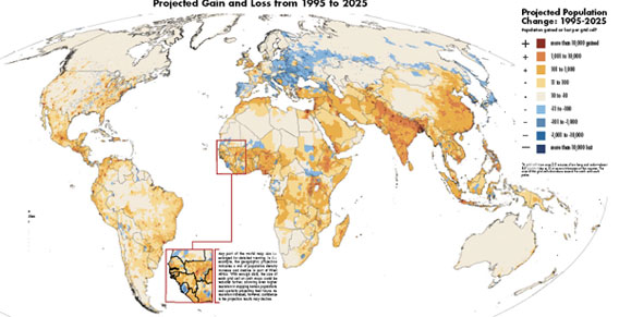
Full-size clickable version of the map
Map copyright and courtesy of Population Action International
The new map projects global human population at 7.9 billion by 2025, midway between United Nations’ estimates of 7.5-8.3 billion by 2025. There are currently about 6.5 billion people on the planet.
This article used information and quotes from an Earth Institute at Columbia University news release.