New York at high risk of flooding from climate change
New York at high risk of flooding from climate change
The Earth Institute at Columbia University
May 17, 2006
For many, sea-level rise is a remote and distant threat faced by people like the residents of the Tuvalu Islands in the South Pacific, where the highest point of land is only 5 meters (15 feet) above sea level and tidal floods occasionally cover their crops in seawater.
Now, however, a recently published study by researchers from The Earth Institute at Columbia University and the International Institute for Environment and Development suggests that as much as 10 percent of the world’s population is vulnerable. In particular, the authors have found that many large cities face risks posed by rising sea level and increased storm intensity.
“Urban areas have traditionally been studied in a way that separates them from their physical surroundings,” says Deborah Balk, a demographer with the Center for International Earth Science Information Network (CIESIN), a member of The Earth Institute at Columbia University. “We talk about urban issues as if they occur in a spatial vacuum, but you can’t address these questions without understanding the spatial dimensions.”
One often-overlooked dimension is elevation. Ten percent of the world’s population lives in coastal areas that are less than 10 meters (33 feet) above sea level, reports Balk and her colleagues. Although they only comprise about 2.2 percent of the world’s land area, these low-elevation coastal zones (LECZs) are home to 600 million people. In addition, about 360 million people in LECZs live in urban areas which means that more people will be exposed to hazards such as sea-level rise and storm surges—phenomena that are expected to worsen as a result of global warming.
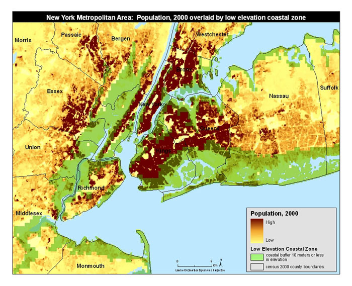 Map of Population and Low-Elevation Coastal Areas in the New York Metrpolitan Region. Click to enlarge RELATED ARTICLES |
The study reports that low-income countries and the Least Developed Countries, a designation used by the Intergovernmental Panel on Climate Change to identify 50 very-low-income nations, in LECZs have a particularly high risk. In particular, Vietnam and Bangladesh have both a high percentage of their total area as well as major metropolitan areas situated inside the LECZ.
Wealthier countries also face significant risks, the researchers say, but have more resources with which to deal with climate variability. However, even with access to economic and technical resources, the challenge of preparing for sea level rise and increases in coastal storms remains difficult for high-income countries. More than 60 percent of the population and land area of The Netherlands, for example is located in the LECZ, and the country has expended vast resources over decades on flood prevention projects. Despite this, they have achieved only mixed results and some efforts been abandoned as ineffective or not cost-effective.
Looking forward, urban areas in low-lying coastal areas may indicate those countries where direct impacts on humans will be especially high in the future. The U.S., in particular, faces significant risk with more urban areas in the LECZ than any other country.
No one geographic or economic indicator can predict risk, the researchers conclude, adding that the different types of cities and coastal zones must be examined in more detail in order to assess the vulnerabilities to climate change faced by different countries: “These results illustrate the importance of looking beyond the small island states to recognize how wide-spread the risks truly are.”
Download the paper in PDF format (181KB).
The Center for International Earth Science Information Network (CIESIN), a member of the Earth Institute at Columbia University, works at the intersection of the social, natural, and information sciences. Scientists at CIESIN specialize in online data and information management, spatial data integration and training, and interdisciplinary research related to human interactions in the environment. CIESIN researchers seek to provide data that informs scientific, public and private decision-makers worldwide.
This is a modified news release from The Earth Institute at Columbia University.