La Nina will not affect 2006 Atlantic hurricanes
NASA/Goddard Space Flight Center
May 4, 2006
NASA oceanographers agree that the recent La Niña in the eastern Pacific Ocean is not expected to have an effect on the Atlantic hurricane season this year. That’s good news, because normally a La Niña tends to increase Atlantic hurricane activity and decrease Pacific Ocean hurricanes.
Although La Niña occurs in the Pacific, it affects weather in the Atlantic Ocean as well, through changes in the winds. La Niña changes the wind patterns in the upper and lower levels of the atmosphere, which make it easier for hurricanes to form in the Atlantic and harder in the eastern Pacific. In the Atlantic, the winds that would normally tear a hurricane’s circular motion apart are lessened but they increase in the eastern Pacific.
The National Oceanic and Atmospheric Administration’s (NOAA) Climate Prediction Center is the federal agency that monitors La Niña conditions such as cooler than normal sea surface temperatures, precipitation and winds. According to their latest report on April 6, 2006, sea surface temperatures were warming back to normal. That latest report stated that during the month of April, sea surface temperatures were slightly cooler than normal in the extreme eastern equatorial Pacific, and conditions returned to near average in that region.
David Adamec, an oceanographer at NASA’s Goddard Space Flight Center, Greenbelt, Md. said that “the current temperature signal at the end of April is near normal and the ocean surface temperature has not yet caused the atmosphere to respond in a La Niña-like way.” Adamec used what’s called a NASA coupled atmosphere-ocean land computer model. This model, developed at Goddard, is used for experimental forecasts of the ocean, land and atmosphere for periods 3-12 months in the future. The data used came from 2 NASA satellites: Jason and QuikSCAT. Jason provided sea-surface height information, and QuikSCAT provided surface wind data.

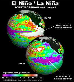
This image shows both the El Nino and La Nina conditions in the central equatorial Pacific Ocean, as seen by NASA’s TOPEX/Poseidon and Jason-1 satellites. El Nino’s warmer waters are indicated in red in this 1997 image, and La Nina’s cooler waters are indicated in blue in this 1999 image. Credit: NASA Pacific wind pattern driving el Nino slows due to global warming Global warming has caused a key wind circulation pattern over the Pacific Ocean to weakened by 3.5 percent since the mid-1800s and scientists warn that it be further diminished by another 10% by 2100. The study, published in the May 4 issue of Nature, says that the weakening of the Walker circulation could could alter climate — including el Nino and La Nina events — and the marine food chain across the entire Pacific region. The Walker circulation, an atmospheric circulation of air at the equatorial Pacific Ocean which spans almost half the circumference of Earth, pushes the Pacific Ocean’s trade winds from east to west, generating rainfall in Indonesia while creating ocean upwelling off the coast of South America that nourishes marine life. |
|
Adamec said that in order for La Niña to have an effect on the Atlantic Ocean hurricane season, it would have to exist for a much longer time, especially into peak hurricane season which is August and September.
Further, he said, another factor associated with La Niña is the Southern Oscillation Index, is also normal. The Southern Oscillation Index is an atmospheric pressure indicator of the large scale surface winds. “La Niña is already a memory,” said Adamec.
According to 12 major ocean-atmosphere computer models, the equatorial Pacific will be neutral to warm in August, when it really matters for hurricanes. August and September are the peak season for hurricane formation in the Atlantic Ocean. According to scientists, the atmosphere takes about two weeks to “react” to a change in ocean surface temperature.
Forecasters and other scientists still expect a greater than average number of Atlantic Ocean hurricanes this year, but La Niña will not be a factor in that. The more active season is expected because of other environmental conditions favorable to hurricanes, such as the location of the Bermuda high removing much of the wind shear in the western Atlantic that thwarts hurricanes, warm sea surface temperatures in the Gulf of Mexico.
La Niña also influences where Atlantic hurricanes form. During La Niña more hurricanes form in the deep Tropics from African easterly waves. Easterly waves are “long waves” in the atmosphere that occur between 5-15 degrees North that start in Africa and move across the Atlantic Ocean. About 60% of the Atlantic tropical storms and minor hurricanes originate from easterly waves.
According to NOAA, these systems have a much greater likelihood of becoming major hurricanes and of eventually threatening the U.S. and Caribbean Islands.
Bill Patzert, oceanographer at NASA’s Jet Propulsion Laboratory in Pasadena, Calif. noted that, “The recent increased frequency of the hurricanes is thought to be part of a larger decades-long cycle of alternating increases and decreases of hurricane activity. The current busy hurricane cycle began in 1995 and could continue for another 10 to 25 years. For the U.S. East and Gulf coasts, the fading La Niña is a real good thing, but Atlantic sea surface temperatures are still very toasty. It’s the summer conditions that will dictate the fall hurricane activity, and I suspect those forecasts will be modified.”
This article is a modified news release from NASA/Goddard Space Flight Center–EOS Project Science Office.


