Ancient water supply of Sahara at risk, satellite monitoring helps in water management
Rhett A. Butler, mongabay.com
December 19, 2005
SUMMARY: During the last Ice Age, the Sahara was savannah with rivers, lakes and plentiful rains. Over the past 10,000 years that landscape changed, but the rains from that period progressively percolated beneath the ground to be collected in aquifers. Today these aquifers are an important source of water for irrigating agriculture and supporting human populations in the area.
The European Space Agency (ESA) has launched a program to monitor the management of this non-renewable resource. Overexploitation risks exhaustion and saline contamination of groundwater, putting the whole region at risk.
A release detailing ESA’s work can be found below.
Sahara’s edge studied from ground, air and space to improve water management
ESA release
An international team worked on the verge of the Sahara to gather data on the ground and in the air, to be compared with imagery of the same region acquired by ESA satellites. The results will be used in support of an ambitious project to apply satellite remote sensing to improve monitoring and management of vast water aquifers concealed beneath the desert.
High-resolution radar as well as hyperspectral optical imagery was acquired during flights across two test areas in southern Tunisia. Meanwhile ground teams precisely documented ground vegetation and terrain at sampling sites within these test areas, with samples taken to local laboratories for detailed analysis. And ESA’s Envisat, ERS-2 and Proba satellites acquired images of these sites around the same time. The aim was to scale up the findings from the ground, and at the same time to use this ‘ground truth’ to calibrate satellite imagery with reality on the sandy arid ground as well as seeing what can be learnt about the water beneath it.
The Sahara has altered through the ages: during the last Ice Age, 10 000 years ago, there was savannah here with rivers, lakes and plentiful rains. That landscape has vanished now, but the rains from that period progressively percolated beneath the ground to be collected in layers of water-bearing rock known as aquifers.
This ‘fossil water’ is today used in North African nations for irrigating agriculture and to support population growth. It is a valuable resource but also a non-renewable one – distributed across national boundaries – which requires careful management to be employed in a sustainable way. Over-exploitation risks exhaustion of groundwater, plus loss of artesian pressure to put remaining supplies out of reach or induce contamination from nearby saline water deposits.
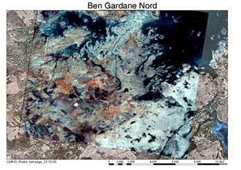 This satellite image of the northern part of the Ben Gardane study area was acquired by the hyperspectral CHRIS image on ESA’s Proba microsatellite during the AquiferEx campaign in Tunisia. It includes ‘red edge’ combinations of spectral bands sensitive to chlorophyll in healthy vegetation. Credits: ESA |
Working with partners including African water agencies, ESA has commenced a project called Aquifer to develop satellite-derived products and services to support the sustainable management of ground water. Planned products include land-use and land-cover maps, change maps, surface water extent and dynamics, digital terrain models and estimates of water consumption and extraction. These required products were identified by the involved water agencies, in Tunisia specifically the Direction Générale des Ressources en Eau (DGRE) under the Ministère de l’Agriculture.
Aquifer takes place within the framework of the TIGER Initiative, aimed at applying Earth Observation technology to improve availability and management of water resources, with a particular focus on Africa.
From November 7, a week-long campaign in southern Tunisia known as the AquiferEx Airborne, Optical and Radar Campaign was overseen by ESA’s dedicated Campaign Unit. AquiferEx involved gathering a baseline dataset to support Aquifer product definition for two test areas of southern Tunisia, the Ben Gardane and Gabès regions. Each about 10 000 hectares in size, these test areas are representative for agricultural crops, natural pastures and irrigation practices.
Both sites are located above the vast North-Western Sahara Aquifer System (better known in French as the Systeme d’Aquiferes du Sahara Septentrional or SASS) and the interconnected Djeffara aquifer on its northern boundary, which stretches across 1 000 000 square kilometres of Algerian, Libyan and Tunisian territory and is one of the working areas of the Aquifer project.
The two sites have significant differences: Ben Gardane to the south suffers from wind erosion and its groundwater is undergoing salinization due to invading sea water. Gabes further north includes several oases and ground water at various levels, but its deep-level fossil water has been exhausted in many places.
A Dornier Do-228 aircraft flown by the German Aerospace Center (DLR) was the platform for two airborne sensors operating simultaneously: the Experimental Synthetic Aperture Radar (E-SAR) built by DLR, which can acquire imagery at differing radar wavelengths and polarisations, and the Airborne Visible Imaging and Infrared Imaging Spectrometer (AVIS), built by the University of Munich, which gathers additional environmental and vegetation information by observing across dozens of spectral bands invisible to the human eye.
“The hyperspectral and radar data of AquiferEx will allow refined land use and land cover mapping,” explained Aquifer Project Manager Stefan Saradeth, of Munich-based GAF AG. “From there it is planned to derive improved estimates of water consumption in agriculturally-utilised areas. AquiferEx also provides a baseline dataset for the validation of other Aquifer results, and the hyperspectral and radar data will be used to develop a range of science products, demonstrating future development lines and showing the potential of new sensors.”
At the same time as the Dornier was flying out of Tunisia’s Djerba International Airport, Tunisian and European participants on the ground gathered information including the size and position of fields, local topography, the soil surface characteristics and vegetation type, distribution and parameters such as leaf area index and wet and dry biomass. Measurements had to be as authoritative as possible, for example close-up three-dimensional photographs were taken of plant rows and soil roughness while sap flow measurements made for olive trees. Samples were analysed in Tunisian laboratories and weather conditions were also documented.
“The conditions for the ground teams were a lot rougher,” said Rolf Scheiber of DLR, who manages the AquiferEx project. “The southern test site of Ben Gardane is a pretty remote place and it took the ground team quite some time to reach it. The accessibility within the site was also restricted even using four wheel drive cars, the northern part of the site could not be reached due to shallow water obstacles. In general, without the cooperation and help of local institutions like the Commissariat Régional au Développement Agricole (CRDA) in Gabes and Medenine and the Institut des Régions Arides (IRA) in Medenine providing guiding experts and lab facilities the performance of ground measurements would have been very limited.”
Related articles Africa Heats Up — climate change threatens future of the continent Global warming has become an increasingly pervasive topic of discussion and concern for the scientific community. From fears over oceanic inundation of low-lying island nations such as the Maldives to glacial melting in the Arctic, higher temperatures around the globe have put experts on edge about the future of the world’s health and balance. Nowhere has the phenomenon become more immediate than for the African continent. A series of recent studies have revealed a sobering future for the majority of Africa, a future predicated by undeniable and significant climate change. The threat traverses all levels of the environmental, social, political and economic spheres, from heightened socio-economic disparity to dwindling fish populations, from civil strife to desperate hunger. Tropical Atlantic cooling and deforestation correlate to drought in Africa
|
Tunisian researchers from the Engineering University of Sfax (ENIS) also participated in ground work, joining personnel from DLR, the University of Munich, and the International Institute for Geo-Information Science and Earth Observation (ITC) in the Netherlands.
“AquiferEx is a good example of the fruitful interplay between satellite remote sensing, air-borne campaigns and ground-truthing,” added Saradeth. “It demonstrates the complementary nature of each and emphasises their individual importance. AquiferEx and Aquifer stand also for successful cooperation between operational water management entities, research and development institutes and private companies spanning Africa and Europe.”
AquiferEx results going to work for Aquifer, and future satellites
Following formal export authorization of acquired radar and hyperspectral data from the Tunisian Ministry of Defence, the AquiferEx results will be evaluated jointly by DLR and the Aquifer project team, including national remote sensing institutes in the SASS countries most prominently Tunisia’s Centre National de Télédétection (CNT) and the European partners GAF AG, the University of Munich, Munich-based company Vista GmbH and Toulouse-based company Scot.
While DLR concentrates on the analysis and interpretation of radar data, CNT and Vista are focusing on the combined evaluation of radar and hyperspectral data for land use and land cover mapping. Data will also be shared with cooperating research partners including ITC. Dedicated CNT-based training sessions on the processing, value adding and use of the AquiferEx data are planned for 2006 in the Aquifer framework.
As with similar campaigns, the results from AquiferEx which are superior in geometric resolution and the number of channels or polarisations to the capability of presently orbiting satellites – will also be used to anticipate the performance and usefulness of future satellite sensors.
Aquifer and TIGER
The Aquifer Project has in addition to SASS a second working area, the Iullemeden aquifer located south of the Sahara and stretching over the territories of Mali, Niger and Nigeria. Aquifer project federates as users the national water Ministries of those three countries, as well as those of Algeria, Libya and Tunisia. The international Sahara and Sahel Observatory (OSS) is the user group co-ordinator for the Aquifer project.
Aquifer takes place as part of the TIGER Initiative, aimed at applying Earth Observation to supply water-related geo-information in support of integrated water resource management for sustainable development. Since its initiation two years ago more than 200 African organisations including water and basin authorities, technical centres, universities and regional organisations – have become involved in different projects around the continent. The hope is to develop a technical, human and institutional capacity to bridge Africa’s water information gap using satellite data.
ESA launched TIGER in 2002, as a response to that year’s World Summit on Sustainable Development (WSSD) in Johannesburg, which stressed the potential of space-based systems to help achieve sustainable economic, social and environmental development.
This is a modified news release (“Sahara’s edge studied from ground, air and space to improve water management“) from ESA.