2006 Hurricane season likely to be active
Colorado State University release
December 6, 2005
The United States faces another very active Atlantic basin hurricane season in 2006, but with likely fewer landfalling intense hurricanes than in 2005 – the costliest, most destructive hurricane season ever – according to a report issued today by Philip Klotzbach, William Gray and the Colorado State University forecast team.
The team’s first extended-range forecast for the 2006 hurricane season anticipates 17 named storms forming in the Atlantic basin between June 1 and Nov. 30. Nine of the 17 storms are predicted to become hurricanes, and of those nine, five are expected to develop into intense or major hurricanes (Saffir/Simpson category 3-4-5) with sustained winds of 111 mph or greater.
The 2005 season witnessed 26 named storms, 14 hurricanes and seven intense hurricanes. Long-term averages are 9.6 named storms, 5.9 hurricanes and 2.3 intense hurricanes per year.
The entire report is available on the Web at http://hurricane.atmos.colostate.edu.
“Our analysis of current and projected global atmospheric and oceanic predictors through November indicates that the 2006 Atlantic basin hurricane season will be an active one with net tropical cyclone activity about 195 percent of the average season,” Klotzbach said.
By comparison, 2005 witnessed tropical cyclone activity that was about 263 percent of the average season.
“Enhanced major hurricane activity is likely to continue in the Atlantic basin for the next 15 to 20 years, but the probability of seeing another two consecutive hurricane seasons with as many landfalling hurricanes as was witnessed in 2004 and 2005 is very low,” Gray said.
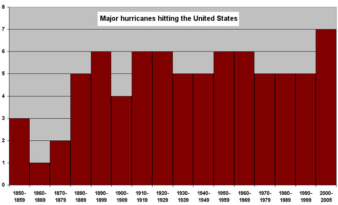 Excerpt from the report: Is Global Warming Responsible for the Large Upswing in 2004-2005 US Hurricane Landfalls?: The recent U.S. landfall of major hurricanes Dennis, Katrina, Rita and Wilma and the four Florida landfalling hurricanes of 2004 (Charley, Frances, Ivan and Jeanne) has raised questions about the possible role that global warming may be playing in these last two unusually destructive seasons. The global warming arguments have been given much attention by many media references to recent papers claiming to show such a linkage. Despite the global warming of the sea surface of about 0.3oC that has taken place over the last 3 decades, the global numbers of hurricanes and their intensity have not shown increases in recent years except for the Atlantic. The Atlantic has seen a very large increase in major hurricanes during the last 11-year period of 1995-2005 (average 4.0 per year) in comparison to the prior 25-year period of 1970-1994 (average 1.5 per year). This large increase in Atlantic major hurricanes is primarily a result of the multi-decadal increase in strength of the Atlantic Ocean thermohaline circulation (THC) which is not directly related to global temperature increase. Changes in ocean salinity are believed to be the driving mechanism. These multi-decadal changes have also been termed the Atlantic Multi-Decadal Oscillation (AMO). There have been similar past periods (1940s-1950s) when the Atlantic was just as active as in recent years. For instance, when we compare Atlantic basin hurricane numbers of the last 15 years with an earlier 15-year period (1950-64), we see no difference in hurricane frequency or intensity even though the global surface temperatures were cooler and there was a general global cooling during 1950-64 as compared with global warming during 1990-2004. |
The CSU hurricane forecast team also predict an 81 percent chance – much higher than average probability – that at least one major hurricane will make landfall on the U.S. coastline in 2006.
The long-term average probability is 52 percent.
For the U.S. East Coast, including the Florida Peninsula, the probability of an intense hurricane making landfall is 64 percent (the long-term average is 31 percent). For the Gulf Coast from the Florida Panhandle west to Brownsville, the probability is 47 percent (the long-term average is 30 percent).
“The probability of landfall for any one location along the coast is very low and reflects the fact that, in any one season, most U.S. coastal areas will not feel the effects of a hurricane no matter how active a season,” Klotzbach said. “However, low landfall probability does not ensure that hurricanes will not come ashore, so coastal residents should always be prepared.”
Florida and the Gulf Coast were ravaged by four landfalling hurricanes in each of the past two years. Hurricanes Charley, Frances, Ivan and Jeanne caused devastating damage in 2004 followed by Dennis, Katrina, Rita and Wilma in 2005.
“In 2004 and 2005, we saw a rare combination of a high number of major hurricanes forming and especially favorable hurricane steering conditions that drove many storms from the deep tropics across the Caribbean and into Florida and the Gulf Coast,” Gray said. “It is statistically unlikely that the coming 2006 and 2007 hurricane seasons will have the number of U.S. landfalling major hurricanes we have seen in the past two years.”
Along with today’s report, the team has updated the Landfall Probability Web site that provides probabilities of tropical storm-force, hurricane-force and intense hurricane-force winds making landfall at specific locations along the U.S. East and Gulf Coasts within a variety of time periods. U.S. landfall probabilities are available for 11 regions, 55 sub-regions and 205 individual counties along the U.S. coastline from Brownsville, Texas, to Eastport, Maine. The Web site, available to the public at www.e-transit.org/hurricane, is the first publicly accessible Internet tool that adjusts landfall probabilities for regions, sub-regions and counties based on the current climate and its projected effects on the upcoming hurricane season. Klotzbach and Gray update the site regularly with assistance from the GeoGraphics Laboratory at Bridgewater State College in Massachusetts.
|
Related articles
2005 Atlantic hurricane season worst on record: US denies hurricane link with climate change: Number of category 4 and 5 hurricanes has doubled over 35 years: Hurricanes getting stronger due to global warming says study: Hurricane Katrina damage just a dose of what’s to come: |
The hurricane team’s forecasts are based on the premise that global oceanic and atmospheric conditions – such as El Nio, sea surface temperatures and sea level pressure – that preceded active or inactive hurricane seasons in the past provide meaningful information about similar trends in future seasons.
For 2006, Gray and the hurricane forecast team expect continued warm tropical and north Atlantic sea-surface temperatures, prevalent in most years since 1995, as well as neutral or weak La Niña conditions – a recipe for greatly enhanced Atlantic basin hurricane activity. These factors are similar to conditions that occurred during the 1961, 1967, 1996, 1999 and 2003 seasons. The average of these five seasons had well above-average activity, and Klotzbach and Gray predict the 2006 season will have slightly more activity than the average of these five years.
Gray does not attribute changes in recent and projected Atlantic hurricane activity to human-induced global warming.
“No credible evidence is available or likely will be available soon that will directly associate global surface temperature change to changes in global hurricane frequency and intensity,” Gray said.
Beginning with this forecast, Klotzbach will step into the lead role for the team’s seasonal, monthly and landfall probability forecasts. Gray has been at the helm for 22 years.
The team will issue seasonal updates of its 2006 Atlantic basin hurricane activity forecast on April 4, May 31, Aug. 3, Sept. 1 and Oct. 3. The August, September and October forecasts will include separate forecasts for each of those months.
This story includes a modified news release from Colorado State University. The original appears at COLORADO STATE UNIVERSITY HURRICANE FORECAST TEAM PREDICTS ANOTHER VERY ACTIVE HURRICANE SEASON FOR 2006