Logging impact worse than thought in the Amazon
“Stealth logging” doubles amount of rain forest disturbance in the Amazon
Rhett A. Butler, mongabay.com
November 1, 2005
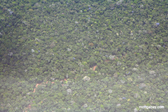
 Logging road in the Amazon. Conventional satellite analysis largely fails to distinguish logged rainforest from pristine rainforest. New methods devised by scientists at the Carnegie Institution of Stanford University measures degradation under the forest canopy. Image by R. Butler. |
Research released earlier this month in Science found that Brazil’s Amazon rain forest is being degraded twice as fast as deforestation figures suggest. Selective logging, where only one or two valuable tree species are harvested from an area, is driving the forest degradation. The findings have important implications for “sustainable harvesting” schemes that have been promoted as ecologically-sound alternatives to traditional harvesting techniques.
The study, conducted by scientists from the Carnegie Institution at Stanford University, looked at data from three NASA satellites — Landsat 7, Terra and Earth Observing 1 — for five Brazilian states between 1999 and 2002 and determined that conventional analysis of satellite data detects only about half the damage caused by timber harvesting by missing degradation that occurs beneath the rainforest’s protective canopy. After developing a new method for analyzing the data, the researchers found that selective logging is highly damaging, creating an additional 60 to 123 percent more damage than deforestation alone while resulting in 25 percent more greenhouse gas emissions than previously believed. Further, selective logging dries out the forest interior increasing the risk of forest fires which spread from nearby agricultural fields. Selective logging has also been correlated to road construction which typically triggers additional deforestation as well as wildlife hunting by timber workers.
New satellite study doubles forest disturbance estimates in Brazil—impacts widespread
Thursday October 20, 2005
News release from the Carnegie Institution of Washington
Stanford, CA. Results from a new large-scale, high-resolution satellite data analysis indicate that forest degradation in the Brazilian Amazon has been underestimated by half. The study, conducted by lead author, Dr. Greg Asner, of the Carnegie Institution’s Department of Global Ecology and colleagues, is published in the October 21, 2005, issue of Science, and has far-reaching ecological impacts for the region and beyond.
For a number of decades, people have been logging specific types of trees in the fragile rain forest by stealthily extracting them one-by-one, with the forest canopy covering their tracks. “We discovered that annually an area about the size of Connecticut is disturbed this way,” explained Asner. “Selective logging negatively impacts many plants and animals and increases erosion and fires. Additionally, up to 25% more carbon dioxide is released to the atmosphere each year, above that from deforestation, from the decomposition of what the loggers leave behind. Timber harvests are much more widespread than previously thought.”

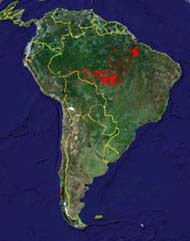
The red areas show where the Asner-led team found selective logging disturbance in Brazil. (The Carnegie Institution and Google-Earth) |
Brazil’s Space Research Institute has used remote-sensing to accurately measure deforestation for over two decades. Surprisingly, though, little has been known about the extent of selective logging in the region because the satellite techniques could not penetrate the shielding upper layers of forest leaves. The Carnegie scientists developed the Carnegie Landsat Analysis System (CLAS) to penetrate this layer by analyzing satellite imagery with advanced computational methods and corroborating the results with selected on-ground field studies. “With the new Carnegie system, we can now see what’s happening from the top of the forest all the way to the soil; we have a whole new picture of the Amazon region and selective logging,” stated co-author Natalino Silva from the Brazilian Agricultural Research Corporation.
From 1999 through 2002, the scientists used remote sensing, with a spatial resolution of 98 ft. x 98 ft. over millions of square miles, and selected on-ground surveys over the five states that account for 90% of all deforestation in the Brazilian Amazon. The annual extent of selective logging was found to be between 4,685 square miles (12, 135 km2) and 7,973 square miles (20,651 km2). A few protected national reserves, parks, and indigenous lands were found to have been logged via illegal activities. As a result of the harvest, up to 80 million metric tons of carbon are released each year. “We expected to see large areas of logging, but the extent to which logging penetrates deep into the frontier is much more dramatic than we anticipated,” remarked co-author Michael Keller of the U.S. Forest Service.
Ecologist Daniel Nepstad of The Woods Hole Research Center added: “This excellent study puts to rest a long-standing debate about how extensive selective logging is in the Amazon. The results are of great concern, since logging punches big holes in the dense forest canopy, increasing the likelihood of devastating forest fire.”
The researchers are hopeful that their new techniques can be expanded to monitor logging in other tropical forest countries. Asner commented: “Our ultimate goal is to provide these satellite results to government officials in Brazil since much of the logging is illegal but difficult to enforce because it is usually clandestine. This will require support from the international community, but the payoffs could be enormous for all of the stakeholders affected by legal and illegal logging and other forest disturbances.”
The new satellite processing system was funded by the Carnegie Institution. Application of this new system to Brazil was supported by the National Aeronautics and Space Administration.
This article contains a modified press release from the Carnegie Institution.


