African lakes disappearing — UN survey
UNEP news release
November 1, 2005
Nairobi, 31 October 2005 The dramatic and, in some cases damaging environmental changes sweeping Africa’s lakes are brought into sharp focus in a new atlas.
Produced by the United Nations Environment Programme (UNEP), the Atlas of African Lakes compares and contrasts spectacular satellite images of the past few decades with contemporary ones.
It was unveiled today at the opening of the 11th World Lake Conference taking place in Nairobi, Kenya.
The rapid shrinking of Lake Songor in Ghana, partly as a result of intensive salt production, and the extraordinary changes in the Zambezi river system as a result of the building of the Cabora Basa dam site beside more familiar images of the near 90 per cent shrinkage of Lake Chad.
Other impacts, some natural and some human-made and which can only be truly appreciated from space, include the extensive deforestation around Lake Nakuru in Kenya.
Satellite measurements, detailing the falling water levels of Lake Victoria are also mapped. Africa’s largest freshwater lake is now about a meter lower than it was in the early 1990s.
Klaus Toepfer, UNEP’s Executive Director, said: “I hope these images of Africa’s lakes will galvanize delegates here at the 11th World Lakes Conference to even greater action to conserve and restore these crucial water bodies. Economically lakes are of huge importance. In the United States, for example, the value of freshwaters for their recreational value alone is estimated at $37 billion a year”.
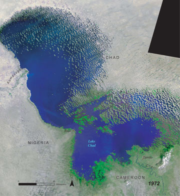 Lake Chad, 1972 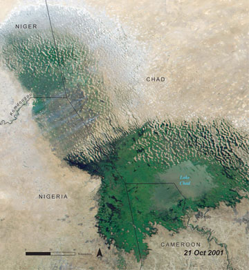 Lake Chad, 21 Oct 2001 Images courtesy of UNEP |
“I also hope that the images will ring a warning around the world that, if we are to overcome poverty and meet internationally agreed development goals by 2015, the sustainable management of Africa’s lakes must be part of the equation. Otherwise we face increasing tensions and instability as rising populations compete for life’s most precious of precious resources,” he added.
Mr Toepfer’s concerns are highlighted in a separate publication, entitled Hydropolitical Vulnerability and Resilience along International Waters in Africa.
Compiled by UNEP and the University of Oregon in the United States, it assesses the strength of legal agreements between countries sharing the Continent’s major water systems.
The report concludes that, in order to reduce tensions between nations, much more needs to be done to beef up shared agreements and treaties to avoid instability in the future.
It points to the Volta river basin in West Africa, shared between Benin, Burkina Faso, Cote D’Ivoire, Ghana, Mali and Togo, as being a particular source of concern.
Over the next two decades, population levels are set to double to around 40 million causing a dramatic demand for water.
Meanwhile rainfall and river flows in the region have declined steadily in the past 30 years with this partly linked to higher evaporation rates as a result of climate change.
“Current water use patterns in the Volts Basin have already stretched the available resources almost to their limits and it will be increasingly difficult to satisfy additional demands,” says the report.
“With the sustainability of the Volta Basin under threat, there is urgent need for basin states to cooperate more closely to jointly manage the basin’s water resources,” it adds.
Some Lake Facts and Figures
The precise number of lakes, both natural and human-made (dams and reservoirs), in Africa is unknown. But the WORLDLAKE database puts the number at 677.
Globally there are an estimated 50,000 natural and 7,500 human-made lakes’.
In Africa Uganda, with 69 lakes has the highest number followed by Kenya, 64; Cameroon, 59; Tanzania, 49 and Ethiopia, 46.
Gabon, with just eight lakes has the fewest in Africa, followed by Botswana, 12 and Malawi; 13.
Africa has about 30,000 cubic kilometers of water in its large lakes making it the largest volume of any Continent in the world.
The annual freshwater fish catch in Africa is around 1.4 million tones of which 14 per cent comes from Egypt.
However the damming of rivers across the Continent allied to the disposal of untreated sewage and industrial pollution has reduced the catch particularly in the Nile Delta and Lake Chad.
Wetlands, often associated with lakes and river systems, are important for wildlife, water supplies and filtering of pollutants.
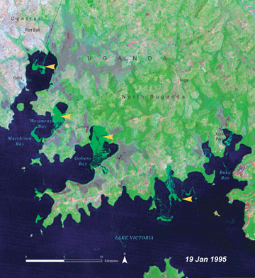 Lake Victoria, 19 Jan 1995 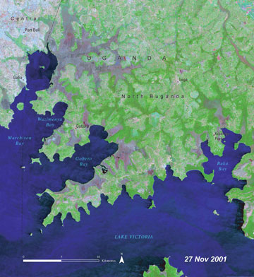 Lake Victoria, 27 Nov 2001 Images courtesy of UNEP |
The most important include those in the Okavango Delta, the Sudd in the Upper Nile, Lake Victoria and Chad basins and the floodplains and deltas of the Congo, Niger and Zambezi rivers.
However, many of being drained as pest control measures or for agriculture. Niger, for example, has lost more than 80 per cent of its freshwater wetlands over the past 20 or so years.
Close to 90 per cent of water in Africa is used in agriculture of which 40 to 60 per cent is lost to seepage and evaporation, says the Atlas.
Specific Lakes
Lake Songor
Lake Songor, a brackish coastal lagoon in Ghana, emerges as one of the most dramatic visual changes in the Atlas. The lake in size is home to fish and globally threatened turtles, like the Olive Ridley and green turtle, as well as important bird populations.
In December 1990, it shows as a solid blue mass of water some 74 square kilometers in size. But by December 2000, the water body is a pale shadow of its former self.
Intensive salt production and evaporation at the western end, seen as dark blue and turquoise squares, is thought to be largely to blame. Agricultural extraction of water from feeder rivers like the Sege and Zano may be also taking its toll.
Lake Victoria
The lake, with some 30 million people living around it, supports one of the densest and one of poorest populations in the world. Around 1,200 people per square kilometer live in and around the lake. Average annual income is less than $250.
An estimated 150,000 square kilometers, equal to 25,000 football pitches, of land has been affected by soil degradation of which 13 per cent has been severely degraded.
The efforts needed to meet the needs of an additional five million people over the next two decades will be immense.
The water level of the lake rose in 1998 as a result of the El Nino rains but, over the last 10 years, it has dropped by about a meter according to measurements by the TOPEX/Poseidon satellite.
Invasive, water hyacinth, has caused havoc to shipping and the fishing industry. However the introduction of a pest to control the weed has had some impact.
Satellite images from 1995 and 2001 show that the green swirls of hyacinth have disappeared from many of the Ugandan bays like Buka, Gobero, Wazimenya and Murchison.
Lake Djoudj
Located 60km from St Louis in Senegal, this lake is a haven for some three million birds such as Great White Pelicans and the Arabian Bustard. It once was a series of thin lakes surrounded by streams, ponds and back waters.
Satellite images underline how the lake and its surrounding area have been changed dramatically since the building in 1986 of the Diama Dam 23 kilometers from the mouth of the Senegal River.
The sheer volume of water available has now shifted local agriculture from seasonal, flood-based farming, to year round irrigation-based agriculture.
The atlas highlights other dramatic changes linked with dams such as the formation of the Lake Cobora Basa on the Zambezi River after the building of a barrage in the 1970s.
The atlas links many ecological and other changes that have occurred since the natural river flow was changed. These include the decline of flood-dependent grasslands, the drying out of mangroves and the fall in water levels on the tributary Shire river which has significantly affected navigation.
The dramatic loss of vegetation and deforestation around Lake Nakuru in Kenya is also vividly seen from space. This may be part of the reason why the lake, according to UNEP experts, declined in area from about 43 kilometers to 40 in 2000.
Satellite images of other key African lakes covered in the atlas include Lake Alaotra in Madagascar; Lake Bin El Ouidane in Morocco; Lake Ichkeul in Tunisia; Lake Kariba in Zambia/Zimbabwe; Lake Nyos in Cameroon; Lake Sibaya in South Africa; Lake St Lucia in South Africa, Lake Tana in Ethiopia and Lake Tonga in Algeria.
This is a modified press release from the United Nations Environment Programme.