25% probability of 7.0 earthquake hitting San Francisco by 2025
Rhett A. Butler, mongabay.com
October 10, 2005

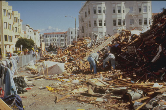
View of Damage along Jefferson Street, in San Francisco’s Marina district. Photo Credit: D. Perkins, U.S. Geological Survey. |
There’s at least a 25% chance of a magnitude 7.0 or greater quake occurring during the next 20 years in the San Francisco Bay Area according to a new computer simulation by researchers at the University of California, Davis. The research is presented in this week’s edition of the Proceedings of the National Academy of Sciences.
According to John Rundle, lead author of the study, the odds of an earthquake striking the Northern California region increase with time. “Virtual California,” as the simulation is known, estimates that is a 50 percent chance of a magnitude 7.0 or greater on the San Francisco segment of the San Andreas fault in the next 45 years, and a 75 percent chance during the next 80 years. The US Geological Survey (USGS) projects 5,800 deaths from a magnitude seven in San Francisco.
The last major earthquake to hit Northern California caused serious damage. On October 17, 1989 at 5:04 pm local time, the San Francisco Bay Area was struck by a quake that measured 7.1 on the Richter scale. The earthquake lasted for fifteen seconds but caused a section of the San Francisco-Oakland Bay Bridge to collapse along with the Cypress structure on the Nimitz Freeway (Interstate 880). At least 66 were killed while 3,757 were injured. The Loma Prieta earthquake caused $6 billion in property damage and was the costliest natural disaster in U.S. history at the time. On October 26, President Bush signed a $3.45 billion earthquake relief package for California.

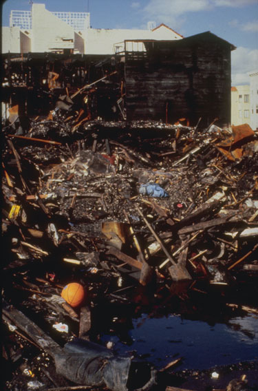
Rubble after the fire at North Point Street and Divisadero in the Marina District. As in 1906 water mains failed and fires in this area could not be fought with city water. Water was pumped from a fireboat to extinguish this fire. Photo Credit: D. Perkins, U.S. Geological Survey. |
Despite the widespread damage, the destruction could have been much worse. The earthquake epicenter was some 70 miles from the San Francisco and Oakland where most of the damage occurred. Seismologists are particularly concerned over potential flooding that could result from an earthquake occurring closer to the Sacramento-San Joaquin Delta. Such a quake could damage the regions levees and produce a situation similar to what happened in New Orleans during Hurricane Katrina with flood water inundating large areas of productive farmland and thousands of homes. A flooded delta would cut off much of California’s freshwater supply — which arrives via an overland aquaduct — for months. According to UC Davis geologist Jeffrey Mount, who is giving a speech on the subject later this week, there is a two-thirds chance that the levees will be damaged by an earthquake or winter storm over the next 50 years. In 1997, floods from snow melt breeched some 50 levees, forcing 100,000 people from their residences and damaging 24,000 homes.
Southern California is also at risk. The Southern California Earthquake Center says is an 80% to 90% chance of a seven or higher hitting Los Angeles within the next 20 years. Such an earthquake would kill up to 18,000 in Los Angeles according to USGS.
This report used information from USGS, The Economist, the Southern California Earthquake Center, Proceedings of the National Academy of Sciences, and Wikipedia.


