Summer wetter, warmer than usual in US says NOAA
NOAA
September 21, 2005
Climate of 2005 – August in Historical Perspective Including Boreal Summer. Image courtesy of NOAA.
The June-August summer season was the tenth warmest on record for the contiguous U.S., while precipitation was above average. Global temperatures were second highest on record for the boreal summer, which runs from June 1 through August 31. Twelve named tropical systems formed in the Atlantic by the end of August, including Hurricane Katrina, which was among the strongest hurricanes ever to strike the U.S., according to scientists at the NOAA National Climatic Data Center in Asheville, N.C.
U.S. Temperature:
NOAA scientists report that the average temperature for the contiguous U.S. for the June-August summer season (based on preliminary data) was 1.2 degrees F (0.7 degrees C) above the 1895-2004 mean. This was the tenth warmest summer on record, with each state experiencing either near average or above average temperatures. Much above-average temperatures stretched from Missouri and Iowa to the Northeast and mid-Atlantic. New Jersey had its warmest summer on record, while New York, Vermont and Massachusetts had their second warmest. Statewide temperatures also were much above average in Florida, Louisiana and Nevada.
The anomalous warmth was not confined to the contiguous U.S. New all-time summer records were established in Honolulu and at the airport on Molokai, Hawaii, where the average seasonal temperatures were 83.1 degrees F (28.4 degrees C) and 78.9 degrees F (26.1 degrees C), respectively. The average summer temperature in Alaska was 2.0 degrees F (1.1 degrees C) above average, the third warmest such season on record for the state.
U.S. Precipitation:
|
HURRICANE KATRINA — MOST DESTRUCTIVE HURRICANE TO EVER STRIKE THE U.S. |
Precipitation was above average for the nation overall but with significant regional variability. Wetter-than-average conditions occurred in much of the Southeast and the central Plains states from Oklahoma to North Dakota and Minnesota. Near-average to drier-than-average conditions occurred throughout the West, except California, which had its twelfth wettest summer on record. Unusually dry conditions occurred in parts of the interior Pacific Northwest that continue to be affected by a multi-year drought. Moderate-to-extreme drought also stretched across much of the area from the southern Mississippi Valley to the upper Great Lakes with drought disasters declared in Arkansas, Missouri, Illinois and Wisconsin during the summer. At the end of August, moderate-to-extreme drought (as defined by a widely-used measure of drought—the Palmer Drought Index) affected 16 percent of the U.S.
Dry conditions also contributed to an active western wildfire season. Through the end of August, more than 3.6 million acres had burned in the contiguous U.S. and more than 3.8 million acres in Alaska. The total of 7.4 million acres for the U.S. as a whole is approaching the record of 8.4 million acres, which burned in 2000.
Atlantic Hurricane Season:
The 2005 Atlantic hurricane season began as the most active on record, with four named storms (Arlene, Bret, Cindy and Dennis) by July 5. Twelve named storms formed by the end of August—the eleventh, Hurricane Katrina, became the most destructive hurricane to ever strike the U.S. It first struck southern Florida on August 25 as a Category One storm. It quickly re-intensified once it moved west into the warm Gulf waters, which were 2-3 degrees Fahrenheit (1-2 degrees C) above normal. Katrina continued to strengthen as it turned toward the northwest and eventually north during the next few days.
Katrina’s sustained winds reached 175 mph (150 knots) and its minimum central pressure dropped as low as 902 millibars (a measure of a hurricane’s strength—the fourth lowest on record for an Atlantic hurricane. The storm’s intensity diminished slightly as it approached the central Gulf Coast, but Katrina remained a strong Category Four storm until landfall along the Louisiana and Mississippi coasts on August 29. Although its intensity at landfall was less than that of Hurricane Camille, which devastated coastal Mississippi in August 1969, the size of Katrina, with hurricane force winds extending 120 miles from its center, was much larger and the destruction more widespread than Camille.
The associated storm surge reached as far east as Mobile, Ala., inundating parts of the city. Large parts of Biloxi and Gulfport, Miss., were covered with water as a result of a 20 to 30-plus foot storm surge that reached far inland. The combination of strong winds, heavy rainfall and storm surge led to breaks in the earthen levee system that separates New Orleans from surrounding lakes and canals, leaving large parts of New Orleans under 20 feet of water.
Globe:
The average global temperature anomaly for combined land and ocean surfaces for the June-August season (based on preliminary data) was 1.1 degrees F (0.6 degrees C) above the 1880-2004 long-term mean. This was the second warmest June-August since 1880 (the beginning of reliable instrumental records). The warmest June-August was in 1998 with an anomaly of 1.2 degrees F (0.7 degrees C) above the mean. Warmer-than-average conditions covered most land areas of the world.
NOAA, an agency of the U.S. Department of Commerce, is dedicated to enhancing economic security and national safety through the prediction and research of weather and climate-related events and providing environmental stewardship of the nation’s coastal and marine resources.
This above was a Sept. 15 press release from NOAA
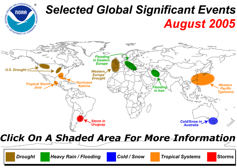
Global weather extremes for August 2005
NOAA’s National Climatic Data Center ran the following on its “Hazards/Climate Extremes Page”
- Drought:
Across the United States, moderate to severe drought persisted throughout parts of the Pacific Northwest eastward into the northern Rockies. Meanwhile, severe to extreme drought expanded across the Mississippi Valley region during August, where some of the worst conditions were observed in Illinois.
For comprehensive drought analysis, please see the current U.S. drought report. Additional information on the western wildfires can be obtained from the 2005 wildfire season page.
African Rainfall Anomalies Long-term drought continued in parts of the Greater Horn and southern Africa, including southern Somalia southward into central and southern Mozambique, southern Malawi and eastern Zimbabwe. For the latest African analysis and forecast, see the Famine Early Warning System Network.
A multi-month drought continued into August in much of western Europe. Since the beginning of October 2004, rainfall has been less than half of normal in areas of the United Kingdom, France, Spain and Portugal. Dry conditions also aggravated wildfires in the region, and nearly 3,000 firefighters battled blazes in Portugal during late August (AFP).
- Flooding:
Flooding affected parts of Bulgaria for the second time in the last two months. A State of Disaster declaration was issued for 22 municipalities in 7 districts located in the western part of the country (OCHA). There were 12,000 people evacuated from their homes in early August, along with a total of 20 fatalities since the flooding began in June 2005 (AFP/OCHA/DPA).Heavy rainfall affected other areas of central and eastern Europe during August, with flooding reported in sections of neighboring Romania, Hungary and Macedonia. The hardest-hit area of Europe was Romania, where 31 flood-related fatalities were reported. Farther to the west, flooding also affected areas of Germany, Austria and Switzerland. At least one death was reported in Germany, with four in Austria and also in Switzerland. Preliminary damage was estimated at over $1 billion (USD) in both Switzerland and Romania (Reuters/AFP).
In Sudan, flooding in early August affected the Darfur and Khartoum states, displacing thousands of people and resulting in at least 8 deaths. Rainfall in Elfashir, North Darfur state on August 3, 2005 totaled 133 mm (5.24 inches), a new daily record since 1918 (IFRC).
In neighboring Ethiopia, 7,500 people in the northeastern part of the country were forced out of their homes as the Awash River rose above the flood stage. At least 5,000 hectares (~12,400 acres) of agricultural land were submerged (DPA). In the Central African Republic (CAR), heavy rain caused the collapse of 3,000 houses and left up to 20,000 people homeless in the capital city of Bangui during early August. The rainy season in the CAR typically begins in mid-July (AFP).
Related articles- Missing Gulfport dolphins rescued following Hurricane Katrina – 16-September-2005
GULFPORT, Mississippi (Reuters) – Wildlife experts on Thursday began rescuing a group of eight bottlenose dolphins swept from their aquarium home into the Gulf of Mexico by Hurricane Katrina. Moby Solangi, president of the Marine Life Oceanarium in Gulfport, Mississippi, said two of the dolphins, 30-year-old Jackie and her 16-year-old offspring, Toni, had been rescued.
Reuters- New Orleans Aquarium animals shipped to Monterey Bay Aquarium – 12-September-2005
Two sea otters and 19 penguins from the New Orleans Aquarium have been sent to Monterey Bay Aquarium. The aquarium will start providing updates on the animals once they have been stabilized. There are currently no plans to place them on exhibit at Monterey Bay.
Monterey Bay Aquarium release- Surviving animals from New Orleans aquarium to be sent elsewhere – 9-September-2005
Surviving animals from the New Orleans will find new homes according to aquarium spokeswoman Melissa Lee. Despite escaping Hurricane Katrina with little physical damage, the Aquarium of the Americas in New Orleans suffered significant loss of animal life when the facility’s emergency generator failed and made conditions unlivable for most its animals.
mongabay.com- Hurricane could hit Los Angeles, San Diego – 8-September-2005
San Diego has been hit by hurricanes in the past and may be affected by such storms in the future according to data from the National Oceanic and Atmospheric Administration (NOAA). While a hurricane in San Diego would likely produce significantly less damage that Hurricane Katrina in New Orleans, it could still exact a high cost to Southern California especially if the region was caught off guard.
mongabay.com
Tropical deforestation affects rainfall in North America – 20-September-2005
NASA research has found that deforestation in the tropics affects rainfall patterns in North America. Deforestation in the Amazon region of South America influences rainfall from Mexico to Texas and in the Gulf of Mexico. Similarly, deforesting lands in Central Africa affects precipitation in the upper and lower U.S Midwest, while deforestation in Southeast Asia was found to alter rainfall in China and the Balkan Peninsula.
NASA
Tampa Bay could be hit by 25-foot storm surge in Category 4 hurricane – 16-September-2005
A Category 4 hurricane could cause a storm surge of as much as 25 feet in Tampa Bay, according to a University of Central Florida researcher who is looking at the risks Florida cities face from tidal surges and flooding.
University of Central Florida release
Number of Category 4 and 5 hurricanes has nearly doubled over past 35 years – 16-September-2005
The number of Category 4 and 5 hurricanes worldwide has nearly doubled over the past 35 years, even though the total number of hurricanes has dropped since the 1990s, according to a study by researchers at the Georgia Institute of Technology and the National Center for Atmospheric Research (NCAR). The shift occurred as global sea surface temperatures have increased over the same period. The research appears in the September 16 issue of Science.
UCAR release
In northeastern Iran, flooding in the Golestan province killed at least 43 people during August 9-10, 2005 (AFP/BBC News).
Flooding and landslides in China were blamed for the deaths of 32 people in the central province of Hubei during late August (Reuters).
Across northern Thailand, heavy rains produced severe flooding in the latter half of August. More than 4,500 villagers’ homes were inundated due to flooding along the Ping River. There were at least 11 fatalities (IFRC).
- Missing Gulfport dolphins rescued following Hurricane Katrina – 16-September-2005
- Severe storms:
In the United States, severe thunderstorms produced a tornado that affected the town of Wright, Wyoming on the afternoon of August 12. The tornado destroyed or damaged more than 80 homes at a mobile home park, rendering 85 families homeless. There were two fatalities (Associated Press).
Severe thunderstorms in Wisconsin generated tornadoes that killed one person and injured at least 30 others on the evening of August 18, 2005. Some of the worst damage was reported around Stoughton, Wisconsin.In Canada, severe thunderstorms produced at least two tornadoes in an area just outside of Guelph, Ontario on the 19th. Cars were overturned and trees downed, although no injuries were reported (Reuters).
In Peru, heavy rains and strong winds were tentatively blamed on a Peruvian passenger plane crash on the 23rd. There were at least 37 deaths and 40 injuries aboard the TANS Boeing 737. Preliminary indications suggested that wind shear, which is the abrupt change in wind speed or direction with height, prompted the emergency landing near Pucallpa (Associated Press/BBC News/CNN).
- Tropical Cyclones:
Typhoon Matsa originated in the northwest Pacific Ocean on July 31 and reached typhoon strength by August 2. Matsa reached the coast of China’s Zhejiang province (near Huangyan) early on the 6th with maximum sustained winds near 140 km/hr (75 knots or 85 mph). The typhoon forced the evacuation of 1.24 million people along the coast, and there were 13 deaths reported (Associated Press/Reuters).Tropical Storm Harvey developed as a depression on the 2nd, and became the earliest-forming eighth storm in the Atlantic on the 3rd. (In those years that have had eight-named storms, the average date of occurrence is September 29). Harvey passed about 50 km (30 miles) south of Bermuda early on the 4th, with heavy rainfall on the island and winds gusting to tropical-storm force.
Typhoon Sanvu developed as a depression in the Philippine Sea before reaching typhoon intensity by the 13th as it trekked across the South China Sea. Sanvu made landfall near Shantou in China’s Guangdong province on the 13th with maximum sustained winds near 120 km/hr (65 knots or 75 mph). There were two deaths attributed to the typhoon (Reuters).
Tropical Storm Jose formed in the Bay of Campeche on the 22nd, reaching the coast of Mexico about 95 km (60 miles) northwest of Veracruz around midnight local time on the 23rd. Maximum sustained winds were near 85 km/hr (45 knots or 50 mph) at the time of landfall. Jose’s primary impact was heavy rainfall.
Typhoon Mawar developed in the northwest Pacific Ocean on the 19th, attaining typhoon status by the 21st. Mawar passed just south of Tokyo, Japan on the 25th with maximum sustained winds near 165 km/hr (90 knots or 105 mph). Very heavy rain fell along storm’s path across coastal Japan.
Hurricane Katrina formed in the southeastern Bahamas as a depression on the 23rd, reaching tropical storm status the next day. Katrina became a hurricane just before landfall in south Florida between Hallandale Beach and North Miami Beach on the evening of the 25th. Maximum sustained winds at the time of landfall were near 130 km/hr (70 knots or 80 mph). There were 11 fatalities in South Florida, including 4 by falling trees. More than 1.3 million customers lost electrical services, and preliminary insured loss estimates ranged from $600 million to $2 billion (USD) in the state of Florida (Associated Press).
Katrina emerged in the Gulf of Mexico during the morning of the 26th and moved west-southwest into open waters of the Gulf while re-strengthening. By the 27th, Katrina reached category-five intensity on the Saffir-Simpson scale. Katrina’s minimum central pressure was observed by reconnaissance aircraft on the afternoon of the 29th at 902 millibars (26.64 inches of mercury), the fourth lowest pressure ever recorded from a hurricane in the Atlantic Basin. The top three include Hurricane Gilbert in 1988 (888 millibars), the Labor Day Hurricane of 1935 (892 millibars), and Hurricane Allen in 1980 (899 millibars). Katrina made landfall in Plaquemines Parish in southeastern Louisiana early on the 29th with maximum sustained winds near 225 km/hr (120 knots or 140 mph), a strong category-four, and the third most-intense landfalling hurricane in U.S. history (according to a minimum landfall pressure of 920 millibars or 27.17 inches of mercury).
The center of the hurricane passed just east of New Orleans, where winds gusted over 155 km/hr (85 knots or 100 mph). Widespread devastation and unprecedented flooding occurred, submerging at least 80 percent of the city as levees failed. Farther east, powerful winds and a devastating storm surge of 6.1 to 10 meters (20-30+ feet) raked the Mississippi coastline, including Gulfport and Biloxi, where Gulf of Mexico floodwaters spread several kilometers (miles) inland. Rainfall amounts of 10-20 cm (8-10 inches) were common along and to the east of the storm’s path. Katrina weakened to a tropical storm as it tracked northward through Mississippi and gradually lost its identity as it moved into the Tennessee Valley on the 30th, dumping heavy rainfall along its course.
In areas of southeastern Louisiana eastward along the Mississippi and Alabama coastlines, thousands of houses and buildings were damaged or destroyed and more than 2.3 million people lost power. Casualty numbers were still incomplete as of September 1, but fatalities will reach into the hundreds or possibly higher. Flooding in New Orleans was expected to make the city uninhabitable for months. Preliminary damage estimates are expected to exceed Hurricane Andrew, which would make Katrina the country’s most expensive weather disaster (Associated Press/CNN).
Typhoon Talim developed on the 25th in the western Pacific Ocean, reaching typhoon strength by the 29th. Talim made landfall in Taiwan late on the 31st with maximum sustained winds near 195 km/hr (105 knots or 120 mph). The typhoon shut down businesses, schools and financial markets and caused 1.48 million power outages. There were 2 deaths and 39 injuries in Taiwan (Reuters/The China Post).
- Extratropical cyclones:
In Uruguay, a powerful storm system on the 23rd-24th produced strong winds in excess of 160 km/hr (100 mph) in the departments of Canelones, Montevideo, San Jose, Colonia and Maldonado, where nearly 70 percent of the country’s population live. Thousands of homes were damaged and around 20,000 people lost electricity and telephone service. Montevideo’s international airport was temporarily shut down late on the 23rd due to the high winds and heavy rainfall. There were seven people killed and dozens injured (Associated Press/OCHA).In Australia, a strong storm system brought heavy rains and strong gusty winds at the end of August. Heavy rains brought flooding to the Meander, Macquarie and South Esk Rivers, plus strong winds exceeding 100 km/hr (60 mph) across south and east sections of the state. Winds gusted as high as 120 km/hr (75 mph) atop Mount Wellingon (elevation 1,271 meters or 4,170 feet) (ABC).
- Severe Winter Weather:
Across southern Australia, snow fell in parts of Victoria, New South Wales and Tasmania on August 10, 2005. It was the first snowfall in Melbourne since July 1986, and the heaviest and most widespread snowfall event since July 19-20, 1951. Numerous records for daily maximum temperatures were also set around the region, as high temperatures struggled to reach between 5 and 8°C (41 and 46°F) in many areas (ABC/BBC News/Australian Bureau of Meteorology.
For full details along with diagrams and satellite images of these meteorological events, check out NCDC Hazards/Climate Extremes