Number of category 4 and 5 hurricanes has doubled over 35 years
UCAR Press Release
September 16, 2005
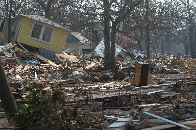 Hurricane Katrina reached Category 5 status on August 28 while churning across the Gulf of Mexico before making landfall the next day at Category 4. The result along the Mississippi gulf coast was damage and destruction like that in Biloxi, shown above. Three hurricanes had already attained Category 4 or 5 status across the gulf by the end of August, an unprecedented total for so early in the season. (Photo courtesy FEMA/Mark Wolfe.) |
BOULDER—The number of Category 4 and 5 hurricanes worldwide has
nearly doubled over the past 35 years, even though the total number of
hurricanes has dropped since the 1990s, according to a study by researchers
at the Georgia Institute of Technology and the National Center for Atmospheric
Research (NCAR). The shift occurred as global sea surface temperatures
have increased over the same period. The research appears in the September
16 issue of Science.
Peter Webster, professor at Georgia Tech’s School of Earth and Atmospheric
Sciences, along with NCAR’s Greg Holland and Georgia Tech’s Judith Curry
and Hai-Ru Chang, studied the number, duration, and intensity of hurricanes
(also known as typhoons or tropical cyclones) that have occurred worldwide
from 1970 to 2004. The study was supported by the National Science Foundation
(NSF), NCAR’s primary sponsor.
"What we found was rather astonishing," said Webster. "In
the 1970s, there was an average of about 10 Category 4 and 5 hurricanes
per year globally. Since 1990, the number of Category 4 and 5 hurricanes
has almost doubled, averaging 18 per year globally."
Category 4 hurricanes have sustained winds from 131 to 155 miles per
hour; Category 5 systems, such as Hurricane Katrina at its peak over
the Gulf of Mexico, feature winds of 156 mph or more.
Other resources: |
"This long period of sustained intensity change provides an excellent basis for further work to understand and predict the potential responses of tropical cyclones to changing environmental conditions", said NCAR’s Holland.
"Category 4 and 5 storms are also making up a larger share of the
total number of hurricanes," said Curry, chair of the School of
Earth and Atmospheric Sciences at Georgia Tech and coauthor of the study. "Category
4 and 5 hurricanes made up about 20% of all hurricanes in the 1970s,
but over the last decade they accounted for about 35% of these storms."
The largest increases in the number of intense hurricanes occurred in
the North Pacific, Southwest Pacific, and the North and South Indian
Oceans, with slightly smaller increases in the North Atlantic Ocean.
All this is happening as sea surface temperatures have risen across
the globe between one-half and one degree Fahrenheit, depending on the
region, for hurricane seasons since the 1970s.
"Our work is consistent with the concept that there is a relationship
between increasing sea surface temperature and hurricane intensity," said
Webster. "However, it’s not a simple relationship. In fact, it’s
difficult to explain why the total number of hurricanes and their longevity
has decreased during the last decade, when sea surface temperatures have
risen the most."
"NCAR is now embarking on a focused series of computer experiments capable of resolving thunderstorms and the details of tropical cyclones," said Holland. "The results will help explain the observed intensity changes and extend them to realistic climate change scenarios."
|


The only region that is experiencing more hurricanes and tropical cyclones
overall is the North Atlantic, where they have become more numerous and
longer-lasting, especially since 1995. The North Atlantic has averaged
eight to nine hurricanes per year in the last decade, compared to six
to seven per year before the increase. Category 4 and 5 hurricanes in
the North Atlantic have increased at an even faster clip: from 16 in
the period of 1975-89 to 25 in the period of 1990-2004, a rise of 56%.
A study published in July in the journal Nature came to a similar conclusion.
Focusing on North Atlantic and North Pacific hurricanes, Kerry Emanuel
(Massachusetts Institute of Technology) found an increase in their duration
and power, although his study used a different measurement to determine
a storm’s power.
But whether all of this is due to human-induced global warming is still
uncertain, said Webster. "We need a longer data record of hurricane
statistics, and we need to understand more about the role hurricanes
play in regulating the heat balance and circulation in the atmosphere
and oceans."
"Basic physical reasoning and climate model simulations and projections
motivated this study," said Jay Fein, director of NSF’s climate
and large scale dynamics program, which funded the research. "These
results will stimulate further research into the complex natural and
anthropogenic processes influencing these tropical cyclone trends and
characteristics."
Webster is currently attempting to determine the basic role of hurricanes
in the climate of the planet. "The thing they do more than anything
is cool the oceans by evaporating the water and then redistributing the
oceans’ tropical heat to higher latitudes," he said.
"But we don’t know a lot about how evaporation from the ocean surface
works when the winds get up to around 100 miles per hour, as they do
in hurricanes," said Webster, who adds that this physical understanding
will be crucial to connecting trends in hurricane intensity to overall
climate change.
"If we can understand why the world sees about 85 named storms
a year and not, for example, 200 or 25, then we might be able to say
that what we’re seeing is consistent with what we’d expect in a global
warming scenario. Without this understanding, a forecast of the number
and intensity of tropical storms in a future warmer world would be merely
statistical extrapolation."
Related sites on the World Wide Web
NCAR Tip Sheet: Hurricane Prediction, Behavior, and Impacts
Georgia Institute of Technology – School of Earth and Atmospheric
Sciences
The National Center for Atmospheric Research and
UCAR Office of Programs are operated by UCAR under the sponsorship of
the National Science Foundation and other agencies. Opinions, findings,
conclusions, or recommendations expressed in this publication do not necessarily
reflect the views of any of UCAR’s sponsors.
Press release from UCAR