NASA assists hurricane victims
NASA release
September 7, 2005
NASA science instruments and Earth-orbiting satellites are providing
detailed insight about the environmental impact caused by Hurricane
Katrina. Images and data are helping characterize the extent of
flooding; damage to homes, businesses and infrastructure; and
potential hazards caused by the storm and its aftermath.
NASA, along with academic institutions and partner agencies, is
working to ensure the Department of Homeland Security and the Federal
Emergency Management Agency have the best available information to aid
in responding to this catastrophic event.
NASA’s partner agencies in this endeavor include the U.S. Geological
Survey, the National Oceanic and Atmospheric Administration, the
National Geospatial Intelligence Agency, the Environmental Protection
Agency, and the U.S. Department of Agriculture.
Coordinated assistance by numerous academic institutions and
laboratories working under NASA grants will be employed by the Gulf
Coast relief and recovery efforts to provide geospatial information
useful to first responders and decision makers.
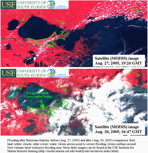
The images above show data from NASA’s MODIS instrument, received and
processed at the University of South Florida’s Institute for Marine
Remote Sensing (IMaRS). In the color scheme in the images, red
normally indicates dry land, while blue indicates water. The top image
shows the same area before Katrina hit, showing red throughout New
Orleans, meaning dry land. The second image was captured on August 31,
2005, showing large areas of New Orleans and the adjacent Gulf Coast
inundated with water. Credit: NASA/USF/IMaRS
NASA aircraft are providing detailed observations of the disaster
area. The aircraft are taking high-resolution observations that can be
used to assess the amount of damage to communities and the
environment. For example, at the request of the U.S. Geological Survey
in cooperation with the Federal Emergency Management Agency and the
Army Corps of Engineers, NASA’s Experimental Advanced Airborne
Research Light Detection and Ranging system is surveying the gulf
coastline.
|
NASA Assistance for hurricane victims NASA has established a public Web site to convey important contact NASA has opened a dedicated toll-free number to take information and The toll free number is: 1-877-470-5240. NASA has a toll-free number 1-888-362-4323 for recorded updates about NASA is also taking email inquiries about personnel sheltering at |
This system, carried on a Cessna 310, surveyed the northern gulf
coastline on Thursday. Tomorrow the aircraft is scheduled to fly over
the perimeter and surrounding levee around New Orleans to assist in
damage assessment of the system.
While making its observations of the land, the system has the ability
to “see” through vegetation, like trees and shrubs, to view the land
underneath. Near the coast it can map the beach surface under water.
This will help in the recovery of the shoreline infrastructure;
determine hazard areas and environmental loss.
The Terra, Aqua and Tropical Rainfall Measuring Mission satellites
have already provided Earth observations for land cover and rainfall.
Terra’s Advanced Spaceborne Thermal Emission and Reflection Radiometer
is providing data on the magnitude and extent of damage and flooding
to the U.S. Geological Survey Emergency Response Team through its
Earth Resources Observation Systems Data Center in Sioux Falls, S.D.
JPL is responsible for the American side of the joint U.S.-Japan
science team that is validating and calibrating that instrument and
its data products.
|
|
NASA’s Moderate Resolution Imaging Spectroradiometer instrument on the
Terra and Aqua satellites provided images of flooding, including pre-
and post-disaster comparisons. Data from NASA’s QuikScat satellite,
developed and managed by JPL, was one source of wind observations used
by the National Oceanic and Atmospheric Administration’s Hurricane
Research Division to analyze the wind field of the storm and to track
its path.
Another NASA satellite in use is the Earth Observing Mission 1. The
Advanced Land Imagery multispectral instrument on this satellite
provided land use and land cover observations useful in determining
hurricane damage areas and in aiding in recovery, response and
mitigation.
NASA satellites are used to improve weather predictions and to study
climate and natural hazards. The knowledge gained during these
missions aids assessment and recovery operations.
For satellite images and additional information on the Web, visit: http://www.nasa.gov/hurricane;
and http://www.aoml.noaa.gov/hrd/Storm_pages/katrina2005/wind.html
.
For information about the Advanced Spaceborne Thermal Emission and
Reflection Radiometer and QuikScat spacecraft on the Web, visit: http://asterweb.jpl.nasa.gov/index.asp;
and http://winds.jpl.nasa.gov/missions/quikscat/index.cfm.
For information about NASA and agency programs on the Web, visit: http://www.nasa.gov/home.
JPL is managed for NASA by the California Institute of Technology in Pasadena.
Alan Buis (818) 354-0474
Jet Propulsion Laboratory, Pasadena, Calif.
Dolores Beasley/Erica Hupp (202) 358-1753/1237
NASA Headquarters, Washington
2005-142
Other resources:
Links to news on shelters in other cities and states Alabama Arizona Arkansas Atlanta Austin Baton Rouge Beaumont Birmingham California Chicago Dallas Florida Georgia Houston Illinois Indiana Iowa Jackson Kansas Kansas City Kentucky Killeen Little Rock Memphis Missouri Montgomery Nashville Nebraska Nevada New Mexico Oklahoma Phoenix San Antonio St. Louis Tennessee Texas Tyler |
Despite escaping Hurricane Katrina with little physical damage, the Aquarium of the Americas in New Orleans has suffered significant loss of animal life. According to the American Zoo and Aquarium Association (AZA), the aquarium has lost most of its fish. A skeleton staff is preparing to move some animals out of the facility and caring for surviving animals in the collection. The sea otters, penguins, leafy and weedy seadragons, birds (macaws and raptors), and the white alligator are fine.
Late last month an atmospheric scientist at Massachusetts Institute of Technology released a study in Nature that found hurricanes have grown significantly more powerful and destructive over the past three decades. Kerry Emanuel, the author of the study, warns that since hurricanes depend on warm water to form and build, global climate change might increase the effect of hurricanes still further in coming years.
The loss of coastal marshlands that buffer New Orleans from flooding and storm surges may have worsened the impact of Hurricane Katrina. In the past, the region’s wetlands have served as a natural buffer that slows hurricanes down as they come in from the Gulf of Mexico and helps protect New Orleans from storms. But all this has changed.