Aerial photos of Hurricane Katrina destruction
Adapted from NOAA releases
September 2, 2005
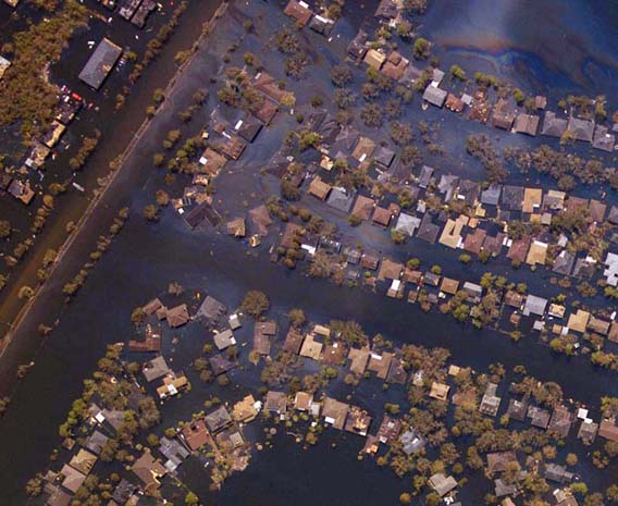
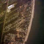
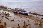
New Orleans, La., where homes were nearly swallowed up by flood waters.
Photo courtesy of NOAA
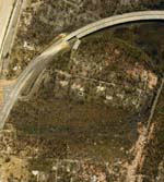
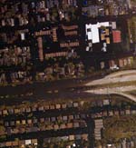
NOAA posted online more than 1450 aerial images of the U.S. Gulf Coast areas that were decimated by Hurricane Katrina. NOAA will be flying more missions in the days ahead that will yield hundreds of additional aerial digital images. The regions photographed on Tuesday range from Bay St. Louis to Pascagoula, Miss. The southeast coastal areas of Louisiana are being photographed on Wednesday. The aerial photograph missions were conducted by the NOAA Remote Sensing Division the day after Katrina made landfall at approximately 7:10 a.m. EDT on Aug. 29, 2005, in Plaquemines Parish, La.
NOAA used an Emerge/Applanix Digital Sensor System, or DSS, to acquire the images from an altitude of 7,500 feet. The equipment was mounted on NOAA’s Cessna Citation aircraft, which is a versatile twin-engine jet aircraft modified for acquiring coastal remote sensing imagery. The aircraft can support a wide variety of remote sensing configurations, including large format aerial photography, as well as data collection for digital cameras, hyperspectral, multispectral and LIDAR systems.
The NOAA Cessna Citation aircraft acquired 3-D images of the World Trade Center and Pentagon just days after the attacks on Sept. 11, 2001.
The NOAA imagery was acquired to support the agency’s national security and emergency response requirements. In addition, the imagery will be used for ongoing research efforts for testing and developing standards for airborne digital imagery.
|
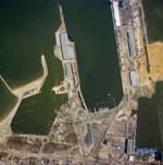
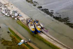
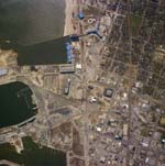 Gulfport, Miss., where the port sustained widespread destruction.
|

NOAA quickly mobilized a wide-range of its resources immediately following Hurricane Katrina’s landfall on the U.S. Gulf Coast. NOAA ships, planes and many experts are helping to assess the damage caused by the powerful storm that is responsible for widespread destruction and loss of life.
NOAA pre-positioned Navigational Response Teams, or NRTs, which are mobile emergency response units equipped and trained to survey ports and nearby shore waterways immediately following the hurricane. These teams can be rapidly transported on a trailer and launched from them for a quick response. This is especially vital to New Orleans, La., and Mobile, Ala., two of the nation’s major commercial ports. The NOAA Office of Coast Survey, working in partnership with the U.S. Coast Guard, the U.S. Army Corp of Engineers and local port management will be coordinating the response.
The Navigational Response Teams use multibeam, sidescan sonars and diving operations to check the port, river or sea bottom for submerged obstructions that could cause hazards to shipping.
The NOAA National Geodetic Survey is using a NOAA plane to take aerial surveys of the impacted areas to assess for damage from erosion, such as occurred to the levees and major evacuation routes. These images will assist both in recovery operations, and long-term restoration and rebuilding decisions. The images will be made available to the public on a NOAA Web site on Wednesday.
The NOAA Office of Response and Restoration and Damage Assessment Center is deploying NOAA scientists and other specialists—in coordination with federal, state and local emergency centers—to assist in evaluating the damages to the many oil and chemical pipelines and platforms in the region.
Water levels, storm surges and flooding are a concern, and NOAA staff is working closely with the Department of Homeland Security and FEMA to coordinate the flow of appropriate information and data that will guide deployment of resources.
The official NOAA web site for Hurricane Katrina is located at http://ngs.woc.noaa.gov/katrina/
Other resources:
- NASA releases satellite photos showing flooded New Orleans following Hurricane Katrina: NASA released satellite photos showing destruction caused by Hurricane Katrina. The images, available on NASA’s Earth Observatory web site clearly show signficant parts of the city inundated with flood water.
- Environmental problems worsened Hurricane Katrina’s impact: The loss of coastal marshlands that buffer New Orleans from flooding and storm surges may have worsened the impact of Hurricane Katrina.
- County updates