
 Taiwan's Feng Chia University has succeeded in boosting the production of hydrogen from biomass to 15 liters per hour, one of the world's highest biohydrogen production rates, a researcher at the university said Friday. The research team managed to produce hydrogen and carbon dioxide (which can be captured and stored) from the fermentation of different strains of anaerobes in a sugar cane-based liquefied mixture. The highest yield was obtained by the Clostridium bacterium.

ESA agrees on ambitious space budget: implications for ecology, climate science
The ministers in charge of space activities in the European Space Agency's 18 Member States today concluded a successful two-day council meeting in The Hague, agreeing on a €10 billion (US$ 12.9bn) budget to undertake new initiatives in several fields and endorsing the next phases of a set of ongoing programmes. Many of the approved projects have a high degree of relevance for the study of climate change, the environment and the management of the planet's natural resources.
The deal was reached after two days of intense negotiations, but ministers agreed with ESA's director general Jean-Jacques Dordain on the relevance of investing in space, especially in a time of economic crisis: space is a key sector providing for innovation, economic growth, strategic independence and the preparation of the future. The ambitious budget, which covers the next three to five years, represents a substantial increase in funding over the previous ones.
French research minister Valerie Pecresse, who presided the council, said that her nation's cash would be spent on those programmes that delivered the greatest gains to society. France, currently holding the European Presidency, is ESA's second largest contributor (after Germany), responsible for about a quarter of the organisation's budget. The focus on the public relevance of investments in space was the leading theme throughout the council.
ESA's space activities can be divided into three types of programmes: voluntary, optional and mandatory. The voluntary programmes include the most expensive activities, including Europe's participation in the International Space Station and its Ariane rocket project. France, Germany and Italy are the biggest backers of these programmes, which contribute up to a third of the budget. The UK focuses more on small optional programmes, and remains a marginal contributor to ESA. However, despite remaining the weak link in Europe's space activities, the country has committed more than expected (€356 million), in exchange for ESA opening a research center in the UK.
Programmes
On the programmatic side, ministers today took decisions concerning the full range of ESA's initiatives. Some highlights:
- Subscriptions for the launcher programmes, including further funding of Europe's space port in French Guiana, Ariane 5 and Vega accompaniment technology programmes, Ariane 5 evolution and the future launchers preparatory programme. The Ariane 5, which has come to dominate the commercial launcher market, will be upgraded to allow it to carry heavier payloads than its current nine-tonne limit. Ariane 5 symbolizes Europe's independence in space. Esa wants to study what comes after Ariane; to consider what the launchers of the future will look like. It will also test the technologies required on demonstration spacecraft such as the Intermediate eXperimental Vehicle (IXV).
- Subscriptions for the Earth Observation activities, including the second segment of the flagship Global Monitoring for Environment and Security Space Component programme (GMES), the Meteosat Third Generation (MTG) development programme and a novel Climate Change Initiative on the provision of essential climate variables. GMES is a major new EO program. It will take the "pulse" of the planet and requires a series new satellites to be launched (more below).
- Subscriptions for the human spaceflight, microgravity and human exploration programmes including exploitation and evolution of the International Space Station, on-board research in life and physical sciences and definition studies on the evolution of a returnable transfer vehicle. Europe will thus take the first step in a plan that could eventually lead to a manned spaceship based on its highly successful unmanned, automated space-station cargo-vessel, known as the ATV.
- Subscriptions to robotic exploration programmes (the ExoMars programme and preparatory activities on future Mars robotic exploration).
- Subscriptions for Advanced Research in Telecommunications Systems (ARTES), focusing on technologies, applications and mission demonstrations and including preparatory work for a European Data Relay System (EDRS), an air traffic management satellite system (Iris) and Integrated Application Promotion combining usage of telecommunications, Earth observation and navigation satellite systems with terrestrial information and communications systems.
- Subscriptions for the programme on the evolution of the European Global Navigation Satellite System, to continue the improvement of Galileo.
The Global Monitoring for Environment and Security (GMES) programme, also known as Kopernikus, has got earth observation and climate scientists all excited. The €2 billion venture will build a full picture of the state of the planet from new satellites and ground-based data. It will be a key tool for the analysis of climate change and the environmental health of the planet:
 energy :: sustainability :: biomass :: bioenergy :: natural resources :: ecology :: climate change :: earth observation :: ESA :: EU ::
 The programme can and will evolve into something which will be of major benefit to mankind; I don't think it is too melodramatic to say that. We need a planetary Earth-observing system to gather all the information to take remedial action on climate and environmental change. - Professor Alan O'Neill, the director of the UK's National Centre for Earth Observation.Through GMES the state of our environment and its short, medium and long-term evolution will be monitored to support policy decisions or investments. GMES will be built up gradually: it starts with a pilot phase which targets the availability of a first set of operational GMES services by 2008 followed by the development of an extended range of services which meet user requirements.
Years of research in the fields of science and technology associated with observation and understanding of the processes and phenomena of the terrestrial environment led in 1998 to the idea to launch GMES. By a combination of measurements at terrestrial level and from space, it rapidly became clear that new operational services could be offered in fields such as oceanography, precise mapping of land use, rapid mapping at times of emergency for the civil protection field or air quality monitoring.
The services provided by GMES can be classified in three major categories:
- Mapping, including topography or road maps but also land-use and harvest, forestry monitoring, mineral and water resources that do contribute to short and long-term management of territories and natural resources. This service generally requires exhaustive coverage of the Earth surface, archiving and periodic updating of data.
- Support for emergency management in case of natural hazards and particularly civil protection institutions responsible for the security of people and property. This service concentrates on the provision of the latest possible data before intervening.
- Forecasting is applied for marine zones, air quality or crop yields. This service systematically provides data on extended areas permitting the prediction of short, medium or long-term events, including their modelling and evolution.
Biomass and bioenergy
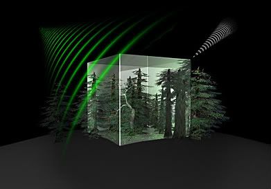
BIOMASS measuring concept
Currently ESA has undertaken the BioSAR 2008 campaign in northern Sweden in order to find out how best to map boreal forest with space borne radar. By answering this question, the campaign addresses one of the key objectives of the candidate BIOMASS mission.
BIOMASS is one of the six candidate Earth Explorer missions that has just completed assessment study and will be presented to the science community at a User Consultation Meeting in January 2009. The next stage of development for the BIOMASS mission, if selected, will be the feasibility study which is expected to greatly improve knowledge of how much and where carbon is being stored, and better quantify carbon fluxes between land and the atmosphere. This knowledge will obviously contribute to the better understanding of the global carbon cycle, climate change, and the bioenergy potential.
To achieve this goal, the BIOMASS mission will exploit the P-band which is the longest radar wavelength available for Earth Observation and is uniquely sensitive to mapping biomass from space. Afterwards highly accurate and robust methods for transforming the P-band radar signals into forest biomass maps are required. Collecting airborne SAR measurements over Boreal Forest and comparing these to extensive ground measurements, will allow a very accurate mapping of the forest biomass.
Given that complete remote sensing dataset and ground data simultaneously acquired are rare for northern forests, the interest of the campaign, beyond the immediate needs of the BIOMASS mission, is expected to be enormous. Finally, once the process has been completed, the dataset will be made available to the wider scientific community through ESA.
EU and ESA convergence
The progressive implementation of GMES is made possible by the activities and investments of European Union and ESA Member States. These and other public and private contributions are jointly supported by the European Commission (EC) and the European Space Agency (ESA).
Together with Galileo, Europe's satellite-navigation system, GMES thus indicates a gradual alignment of ESA and the EU. Currently, these are distinct legal entities which do not share the same membership; ESA counts some non-EU nations among its membership. But space is now of such high political and economic importance that these two entities are expected to "converge" in the future.
References:
ESA: European Ministers inject new impetus to ensure space’s role as a key asset in facing global challenges - November 26, 2008.
ESA: Ministerial Council 2008.
Global Monitoring for Environment and Security homepage.
GMES: BIOMASS Mission - 19 Nov 2008
ESA: ESA leads the way to map boreal forest - October 20, 2008.
posted by Biopact team at 10:02 PM
![]()
![]()


1 Comments:
well written informative post.keep on posting.
regards
Map digitization
Post a Comment
Links to this post:
Create a Link
<< Home