
 Mongabay, a leading resource for news and perspectives on environmental and conservation issues related to the tropics, has launched Tropical Conservation Science - a new, open access academic e-journal. It will cover a wide variety of scientific and social studies on tropical ecosystems, their biodiversity and the threats posed to them.


A burning issue: satellite data show very large potential of rice straw as bioenergy feedstock
Milap Punia from the Center for the Study of Regional Development at the Jawaharlal Nehru University, and Vinod Prasad Nautiya and Yogesh Kant, both from the Indian Institute of Remote Sensing, first sketch the scale and seriousness of the current practise: setting fire to millions of tonnes of crop residues releases vast amounts of greenhouse and trace gases (CH4, CO, N2O, NOx), which heavily contribute to global warming and result in perturbations to regional atmospheric chemistry. The resulting air pollution is an important health hazard for Punjab's population. Weather patterns can change because of the aerosols that enter the atmosphere as a result of the burning.
The reason why most farmers burn off the straw is the lack of a market for the resource. Currently, rice straw has no commercial value. Its disposal rather constitutes an extra cost. Ploughing it into soils is time and energy consuming, and the residues take a long time to decompose. Burning the straw on the field is the most economic and easiest way to get rid of it.
But the good news is that this "burning problem" - an unhealthy cocktail of serious air pollution leading to respiratory illnesses, large emissions of climate-destructive gases, and a huge wastage of energy - can be turned into a bright green future simply by using the resource as a feedstock for modern bioenergy production.
Modelling Satellite Data
The scientists attempted to estimate the total area per district affected by rice straw burning. To do so, they relied on both low resolution (MODIS) and moderate resolution (AWiFS) satellite data. The model looks at the thermal channels of MODIS and complements it with a knowledge-based approach for AWiFS data. A hybrid contextual test-fire detection and tentative-fire detection algorithm for satellite thermal images was designed to identify the fire pixels over the region. The algorithm essentially treats fire pixels as anomalies in images and can be considered a special case of the more general clutter or background suppression problem. It utilizes the local background around a potential fire pixel, and discriminates fire pixels, avoiding the 'false alarm'. The model incorporates the statistical properties of individual bands and requires the manual setting of multiple thresholds.
In addition, a decision-tree classification based on the See5 algorithm was applied to the AWiFS data. When combined with image classification using a machine learning decision tree classification, this approach gives a high accuracy. The study then compared the estimated burned area over the region using the two algorithms.
Punjab on Fire
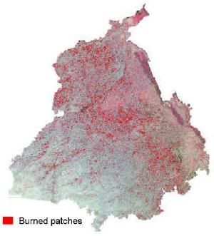
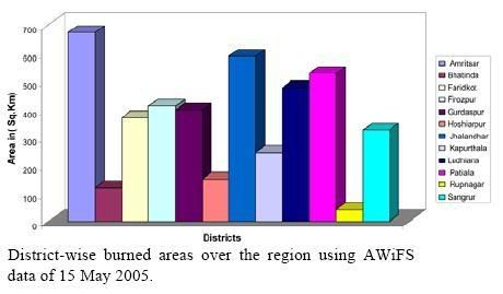 Expressed in terms of the acreage that was burned on that same day, the analysts found that a total of 4315.35 square kilometres was affected (graph, click to enlarge). Among the most active districts were Amritsar, followed by Jhalandhar, Ludhiana, Firozpur and Patiala.
This is the first time that such a detailed graphical and statistical set of data is produced showing the extent of the practise of rice straw burning. Mapping of burned biomass has proved to be a difficult task in the past, but remote-sensing tools now seem to be promising:
 energy :: sustainability :: biofuels :: biomass :: bioenergy :: crop residues :: rice straw :: burning :: emissions :: air pollution :: climate change :: remote sensing :: Punjab ::
 In a future step, the results obtained from analysing the satallite data will have to be checked and complemented by field observations, in order to validate them.
Using the resource wisely
The very large amount of rice straw that is burned in the open air each year in Punjab is an extreme form of waste. The energy contained in the biomass gets lost, as do valuable soil nutrients, mainly N and C in the topsoil layer.
The practise further contributes very strongly to regional air pollution and global warming. On a planetary scale, the burning of biomass in the open air is recognized as contributing as much as 40% of gross carbon dioxide and 38% of tropospheric ozone. It has a significant impact on the atmospheric chemistry and biogeochemical cycles, radiative energy balance and climate.
In the year 2000, the emission of CH4, CO, N2O and NOx has been estimated to be about 110, 2306, 2 and 84 Gg respectively from rice and wheat straw burning in India.
Add the fact that local air pollution can make life during the burning season extremely uncomfortable. Respiratory illnesses resulting from this practise are a significant disease burden on Indian society.
All these different problems can be tackled at once by one single intervention: using the biomass resource in modern bioenergy production units. This captures the energy in the residues, which now gets lost, and cuts both air pollution levels and greenhouse gas emissions as the bioenergy is used instead of fossil fuels.
There are many pathways for the conversion of this vast resource of unused rice straw into useful energy products - from liquid biofuels and biohydrogen to alternatives for coal or natural gas. Each one of these has its advantages and disadvantages.
The biomass material can be densified close to the field (e.g. torrefaction combined with pelletization) and brought to small, medium or large scale energy plants. The bioenergy facilities can be kept local and meet the energy needs of rural households, or be centralized and supply electricity to the grid.
Alternatively, the straw can be used as a feedstock for the simultaneous production of clean energy and biochar. Biochar can be sequestered as stable C into the soils from which the straw was removed. This approach would contribute to boosting the fertility of these soils, and would generate carbon credits.
The choice for any particular utilisation pathway depends on a myriad of social, economic, environmental, and infrastructural factors. But it is clear that the worst way to use the straw is to burn it in the open air, as is currently done.
The work of Milap Punia, Vinod Prasad Nautiya and Yogesh Kant shows that the analysis of satellite images can go a far way in helping us understand the regional availability of biomass resources. This kind of research will also determine how much of the organic matter should be returned to the soils in order to ensure that its use as a source of energy remains sustainable.
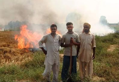
Picture: Punjabi farmers burn the rice straw that remains after the rice harvest. The practise represents a waste of energy and soil nutrients, and contributes to local air pollution and climate change. Credit: USDA/FAS.
References:
Milap Punia, Vinod Prasad Nautiya and Yogesh Kant, "Identifying biomass burned patches of agriculture residue using satellite remote sensing data", Current Science, vol. 94, n° 9, 10 May 2008.
posted by Biopact team at 4:53 PM
![]()
![]()


0 Comments:
Post a Comment
Links to this post:
Create a Link
<< Home